The curious thing about a water dashboard is what it counts. Reservoirs are obvious. Rivers, certainly. But soil moisture? In Andhra Pradesh’s Water Resources Information and Management System, water held in the soil belongs in the picture too. A field can look dry from the road while holding something valuable underground. To manage water, you first have to decide where to look.
- Vassar Labs connects sensors, satellite images and administrative records.
- Governments and utilities use its platforms for water, farms, floods and cities.
- Its practical advantage is joining forecasts to the workflows that follow.
That is a useful introduction to Vassar Labs. Its products assemble observations scattered across agencies and turn them into maps, forecasts and tasks. The interesting question is whether the person making a decision can finally see enough of the system to make it well.
The water hiding in plain sight
Founded in 2014, Vassar Labs lists Laxmiprasad Putta as founder and managing director, Nikhilesh Kumar as co-founder and climate-tech CEO, and Chandrakiran Mallarapu as co-founder. Its technical vocabulary includes geospatial AI, remote sensing and digital twins. Its operating territory is wonderfully physical: reservoirs, crops, groundwater and distribution pipes.
The World Bank described its role neatly in a 2020 water-innovation overview: water management and forecasting for state agencies using satellite imagery, in-situ sensors and predictive analytics. That places it between an observation and an operating decision. A satellite can show a waterbody. An agency still needs to decide what the observation means for supply, irrigation or risk.
aquaWISE is the water platform underlying much of this work. Its product family extends into irrigation, reservoir operations and urban supply. The appeal is a connected view of resources whose movements ignore the lines on a departmental organization chart.
A forecast needs a destination
In Kerala, Vassar Labs’ case study describes a 2021 contract with the Irrigation Design and Research Board for a flood forecasting and early warning system in the Periyar-Chalakkudy basin. The region’s steep terrain and intense rainfall make the timing of water movement consequential.
aquaFLOOD combines weather forecasts, river and rainfall gauges, and catchment conditions. Hydrologic models estimate runoff; hydraulic models follow water through channels and floodplains. The resulting maps describe likely flood extent and depth, helping authorities consider evacuations and resource placement. The company describes shared APIs bringing in existing departmental measurements. Connecting instruments already in service is part of the work.
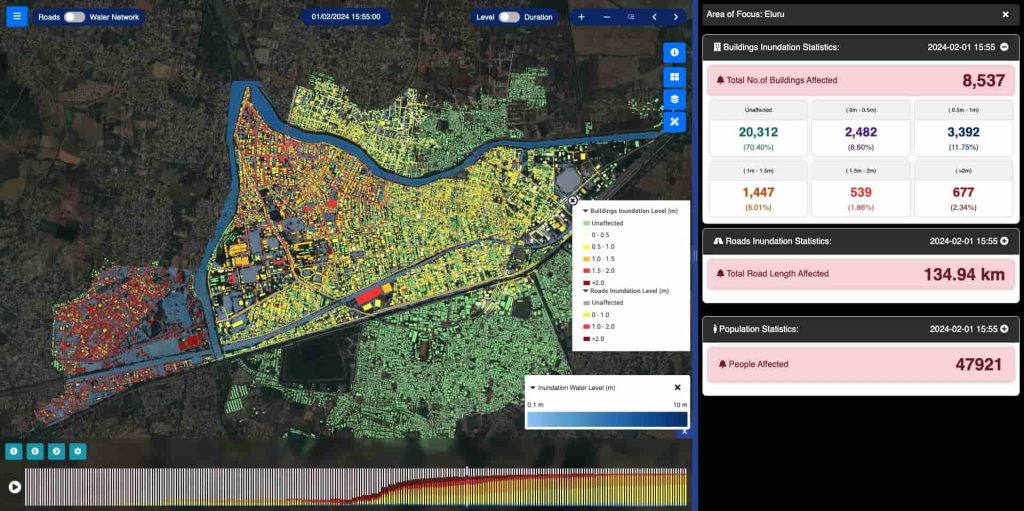
Distribution matters as much as modeling. A September 2026 metWISE submission published by NITI Aayog’s Frontier Tech repository reports climate alerts reaching approximately three million farmers through state programs. It describes dashboards, mobile applications and WhatsApp delivery. These are reported reach figures in a repository that explicitly does not independently validate submissions.
Conceptual sequence, not a forecast-accuracy chart.
The farmer is not the procurement department
fieldWISE applies a similar approach to agriculture: combine field boundaries, weather and crop observations, then make advice relevant to a particular plot. Its offerings cover crop monitoring, irrigation, pests and fertilizer decisions. The institutional customer and the ultimate user can be different people, separated by several layers of administration.
Google’s October 2025 announcement said Vassar Labs planned to integrate its Agricultural Landscape Understanding and Agricultural Monitoring & Event Detection APIs into fieldWISE. Google described the existing platform as serving more than ten million Indian farmers through state projects. That is distribution through public systems; it should not be read as ten million paying subscribers.
Even a pipe needs paperwork
A city water network adds another complication: customers. aquaCITY pairs network monitoring and leak alerts with billing, connections and grievance handling. A utility has to repair the pipe, account for the water and answer the person whose tap stopped running. Software that connects those jobs has a different brief from a map that merely displays assets.
The broader cityWISE platform extends into urban governance. A July 2026 Frontier Tech submission reports more than 600,000 municipal service requests processed across deployments in three states. This is the less photogenic side of climate technology: land records, tax receipts and service queues. It is also where decisions accumulate.
The business behind the dashboard
Vassar Labs sells to institutions with existing infrastructure and particular requirements. Its water offering allows SaaS or deployment on customer infrastructure. An Economic Times report from 2019 described fees for customization, integration and platform licenses, varying by complexity and modules.
Its market position rests on combining domain models with integration and daily workflows. In the World Bank’s overview, neighboring approaches include SatSure’s satellite-based irrigation monitoring and SmartTerra’s utility intelligence. Buyers can also assemble mapping, telemetry and modeling separately. Vassar’s pitch is to connect those pieces around an institution’s work, with the configuration that entails.
That report called the business bootstrapped and put FY2018-19 revenue at approximately $3.5 million. It also recorded a strategic adjustment: Kumar said Google Launchpad mentoring helped with delivery, sales and product management. Growing the business required attention to how projects were sold and delivered alongside the engineering.
Go outside and check
An early independent assessment offers a useful brake on dashboard enthusiasm. In 2018, SANDRP’s review of APWRIMS praised its breadth while questioning groundwater accounting and noting that more ground-truthing remained necessary. Kumar explained that updates depend on incoming data. Freshness and completeness are separate properties.
“This is updated every 15 mins, as and when the data comes.”
Nikhilesh Kumar, on APWRIMS, 2018
For a prospective buyer, the lesson is practical: start with a decision, identify the measurements it requires, verify them locally and assign responsibility for acting. Missing observations, poorly calibrated models or warnings without an operational owner can weaken the chain. That is an inference from the system’s dependencies, rather than a measured verdict on every deployment.
The company’s range also includes hydropower optimization. In 2023, Vassar Labs took third place and $15,000 in the US H2Os Prize final, where teams faced an unexpected wildfire while scheduling water releases. The exercise captures the underlying problem rather well. Water has several jobs. The people assigning those jobs need to see what everyone else is asking of it.
2023 H2Os Prize final
Follow the water
Explore the products, the people and the demonstrations.