The origin myth of ikeGPS contains a Land Rover, a filing cabinet and a hungry lion. In the late 1990s, electrical engineer Leon Toorenburg was maintaining police radio links in Kenya. He drove long distances to remote towers, photographed them, scribbled their locations and later tried to reconcile the evidence. The process was slow, imprecise and occasionally placed him on the wildlife menu. During those drives, he began imagining one tool that could put a photograph, a location, a compass bearing and a laser measurement into the same record.
He brought the idea home to New Zealand and founded ikeGPS in 2003. The first commercial system, delivered to the U.S. Army Corps of Engineers in 2008, was an expensive hand-held instrument built for difficult field work. Early versions cost more than US$10,000. The technology even found its way into post-Hurricane Katrina imagery. It was clever hardware, and that was also the problem: a device can capture a measurement, but a customer’s expensive work begins after the shutter clicks.
Today, the company is headquartered in Broomfield, Colorado, listed in New Zealand and Australia, and still engineered in large part from Wellington. Its pitch has become wonderfully narrow. ikeGPS calls itself “the PoleOS company.” It helps electric utilities, communications providers and their engineering firms collect, measure, model and manage utility poles. The pole sounds dull. The workflow around it is not.
The expensive object nobody notices
A single wooden pole may carry electric distribution lines, fiber, cable television, streetlights and equipment belonging to several organizations. Before another attachment goes up, somebody must establish what is already there, who owns it, whether clearances satisfy the National Electrical Safety Code and whether the structure can take more load. A bad record can mean another truck roll. A bad calculation can mean a rejected permit, an overloaded pole or a safety problem with lawyers attached.
The old method often involved two people, a height stick, a clipboard, a separate camera and a great deal of standing near traffic or energized equipment. IKE’s approach collapses the field kit. A solo technician photographs and measures from a safer distance with the orange IKE Device. Its calibrated camera, laser rangefinder, GPS or RTK positioning and guided forms produce a structured record. The data moves into IKE Office Pro, where an analyst measures attachments, checks quality, maps the work and exports it into engineering or asset systems.
PoleForeman handles structural analysis: spans, line angles, wire sizes, equipment, clearances and strength utilization. IKE Analyze supplies the human back office for customers that would rather send the imagery out. IKE Insight automates narrow jobs such as finding double poles and preparing joint-use tickets. Training matters enough to be a separate product line. The business is less a gadget than a connected production system.
The customers changed the company’s mind
The first version of ikeGPS was a pure hardware company serving defense, geospatial and surveying work. The decisive change arrived around 2013, when U.S. utility customers asked for software tailored to electric distribution. Management followed the request. Instead of trying to measure everything for everyone, ikeGPS began owning more of one customer’s pole workflow.
That shift also changed the economics. A hardware sale is irregular. An annual software seat renews. A processed pole can generate a transaction. A managed analysis project produces service revenue. Training and integrations make the system harder to dislodge. In FY26, ikeGPS reported NZ$26.6 million in total revenue, including NZ$19.2 million of platform subscription revenue. Subscription gross margin was about 94 percent. By June 2026, the annualized subscription exit run rate was roughly NZ$22 million.
It was not a cheap reinvention. The 2014 public offering raised NZ$22.8 million. In 2019, the company agreed to pay US$3.4 million for selected assets of PowerLine Technology, including PoleForeman, with cash, shares and an earn-out. In 2021, it paid US$3.3 million in cash for Visual Globe’s utility-imagery AI assets, with additional contingent consideration tied to performance and retention. A 2025 equity raise targeted about A$20 million to fund more product development.
The PoleForeman purchase is the cleanest proof of the strategy. PowerLine Technology had been an integration partner for years and came with more than 100 North American customers. The fit was known before the cheque was written. After rebuilding the platform with a council of large utility customers, ikeGPS said PoleForeman reached about NZ$11 million in annual recurring revenue within two years of launch. Public pricing now starts at US$2,500 per seat annually for individuals and small teams. Enterprise pricing remains negotiated.
Proof arrives one pole at a time
The customer list runs from contractors to some of North America’s biggest infrastructure owners. Public materials name AT&T, Crown Castle, Corning Optical Communications and ALLO Communications, along with engineering firms including TWiG Technologies, Cyient, Horrocks and Luck Grove. In its latest quarter, ikeGPS reported 476 enterprise subscription customers. Its software operates in all 50 states and is used by eight of North America’s 10 largest investor-owned utilities and five of the 10 largest U.S. communications companies.
The more revealing evidence comes from ugly projects. A major utility asked TWiG to audit more than 200,000 poles in six months, through a Chicago winter and a pandemic. Hot-stick collection was slow and created safety problems. TWiG paired IKE devices and forms with office measurement, dashboards and standardized reports. It tripled its field production rate, cut recollects in half, finished on time and reported zero pole rejections. The technology worked because the process around it changed too: crews were trained, forms matched the job and office reviewers received consistent records.
Luck Grove offers a different scale test. The engineering and construction firm logged more than 220,000 IKE collections in 2025, roughly 600 a day, and ran the most-used device in IKE’s customer base. That number says less about a laser than it does about repeatability. Enterprise field technology wins when the hundredth collection is as boring as the first.
AI with a job description
PolePilot, launched in October 2025 inside IKE Office Pro, is ikeGPS’s most legible AI product. It does not promise to reinvent the grid. It looks at pole photographs, identifies items such as power lines, communications lines, transformers and streetlights, estimates heights of attachment and arranges the labels for review. The company says the assistant can make annotation about 30 percent faster.
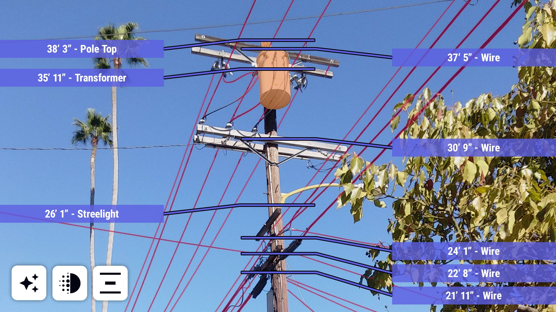
Customers quoted by ikeGPS emphasize consistency and faster quality control, not magic. That is the right standard. Pole imagery can be messy: leaves hide equipment, camera angles distort height and overlapping wires look like spaghetti drawn against the sky. PolePilot processes only the calibrated IKE photos in its workflow, and results may take up to 12 hours. It gives an analyst a head start; it does not eliminate expert review.
The commercial result is more interesting than an accuracy benchmark. ikeGPS says PolePilot supported a roughly 10 percent price increase across the IKE Office Pro subscription base without reported churn. That is AI with a receipt. In July 2026, management also disclosed IKE Vitruvius, an internal AI platform used by product, engineering, sales and marketing teams. Three more customer products were planned for the second half of FY27, including make-ready engineering automation, distribution-grid management and a structural product for fiber builders. Those products are promises until they ship.
What failed first - and what survived
The hardware did not fail technically. It failed as the center of the business. Revenue from devices was episodic, while customer value accumulated in records, analysis and approvals. The broader-market Spike product makes the lesson visible. Spike attached a laser to a smartphone for signage, architecture and general field measurement. It won an industry award, integrated with AutoCAD and ArcGIS, and claimed thousands of signage users. In August 2026, ikeGPS announced the product family’s end of life. Hardware sales will stop in September; cloud services are scheduled to close in February 2027.
The unglamorous truth
Spike tried to make measurement broadly accessible. PoleOS makes one expensive industrial workflow deeply dependable. The narrower idea produced the stronger recurring business.
Another weakness is volatility outside subscriptions. Large communications projects can finish, taking transaction volume with them. Services add completeness and customer stickiness but carry lower margins. In its June 2026 quarter, subscription revenue rose 27 percent while total revenue stayed flat because services softened. Concentration among large infrastructure buyers also means long procurement cycles and timing that a vendor cannot fully control.
The playbook worth stealing
There are five copyable moves here. Start with field observation, not a software category. Capture the record once and make it useful to every downstream step. Let demanding customers define the adjacent module. Integrate with rival tools when customers already trust them. Then price around continuing work - seats, assets and analysis - instead of the initial device.
Copy this
- Study the hazardous manual job in person.
- Turn raw capture into a shared system of record.
- Use customer councils to specify adjacent products.
- Prove AI with minutes saved or errors avoided.
Do not force it
- When a phone photo is accurate enough.
- When the job is tiny and rarely repeated.
- When no engineering or compliance step follows.
- When teams will not standardize forms and training.
The system is not automatically right for every survey. A small contractor measuring a handful of signs may be better served by a phone app or ordinary laser. A drone makes more sense for corridor inspection or vegetation work. A total station can be appropriate when a licensed survey demands its method. IKE becomes compelling when teams must capture many assets safely, reproduce measurements, defend structural decisions and feed data into permitting, GIS and construction. Without that downstream complexity, the specialist stack is overhead.

Internally, ikeGPS uses the Māori word manaakitanga: rise by lifting others. The idea appears in its hybrid-work policy, customer training and stated values, which include simplicity, clarity, ingenuity and “openness with no bullsh*t.” The phrase is unusually direct for a public company. It also describes the product constraint. A pole record is useful only when the fielder, analyst, engineer, owner and attaching company can all lift the same project.
That is where ikeGPS sits in the market. O-Calc Pro, SPIDAcalc and PLS-CADD compete in structural analysis; Katapult Pro and GIS platforms overlap in collection and workflow; total stations, drones and hot sticks compete in the field. IKE integrates with several of those structural tools because the customer’s installed process matters more than a pristine competitive diagram. Its distinction is the connected route from field capture to cloud record, code-aware model, managed service and pole-specific automation.
The company began by asking how to measure a distant object without walking up to it. The better question turned out to be what everyone needs to do after the measurement. By answering that, ikeGPS found recurring software revenue inside a utility pole - and discovered that a narrow market can still run through every town in America.