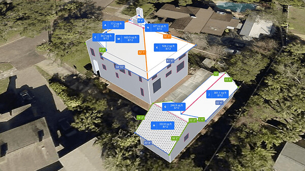
The first roof in Eagleview's history was small enough to hold in two hands. In 2006, Southern California roofing contractor Dave Carlson told his brother-in-law, Seattle software engineer Chris Pershing, about a stubborn part of the job: measuring roofs was slow, risky and easy to get wrong. Pershing began testing software on his wife's ornamental birdhouses, turning ordinary photographs into three-dimensional roof models. The pair had found a wonderfully unglamorous wedge - remove the ladder from the estimate.
They launched EagleView in February 2008 as a remote aerial roof measurement service. A contractor could order a report instead of sending someone up with a tape. An adjuster could work from the same geometry. Materials could be bought against a third-party number rather than a hopeful sketch. The company did not need to persuade customers that roofs existed. It only needed to prove that pixels could become measurements people trusted.
The product is a remote opinion people agree on
Eagleview now sits in a category broader than roof reports. Its 100-aircraft fleet captures both orthogonal images, looking straight down, and oblique images, looking from an angle. Those views feed measurements, historical comparisons, 3D models and machine-learning signals. The company says its library contains more than 3.5 billion images, covers 96 percent of the U.S. population and rests on more than 300 patents.
Its customers follow the physical life of a property. Roofers use measurements for bids and material orders. Insurers use them to settle claims. County assessors look for additions that never reached the tax roll. Utilities inspect corridors and vegetation. Solar installers need pitch, shade and obstruction data before placing panels. Emergency managers compare the world before and after a storm. The underlying asset is the same scene; the product changes with the decision.
That last number hints at the less obvious product. Eagleview sells agreement. Contractors describe its measurement as a center point insurers recognize. In a claim, the useful output is not only square footage; it is fewer arguments about square footage. Software that becomes a common language between two parties can be sticky even when a cheaper tool produces a plausible answer.
“I ran the experiment.”Jen Silver, owner of Roofing Utah
The cheaper answer failed in the warehouse
Roofing Utah offers the cleanest account of what Eagleview actually did, what it cost and what changed a buyer's mind. Owner Jen Silver knew Eagleview was more expensive, so her team tried a lower-priced report alongside hand measurement. The failure did not first appear on a screen. It appeared as excess inventory. She said the alternative's roof-square count ran 10 to 15 percent high, which drove roughly 30 percent more material ordering and left about 20 percent unused.
Silver then compared the alternative and Eagleview across eight projects. That small controlled test changed the decision. Her published case study attributes $93,000 in annual savings, $1,550 in net savings per Eagleview order and a 25-times return to reducing material surplus. These are one customer's results, not a universal promise, but the experiment is copyable: test competing measurements on the same jobs, then count material, labor, supplements, truck rolls and warehouse residue. Do not stop at the report fee.
The public price gives the comparison some shape. In 2026, Eagleview lists a small Premium roof report at $32.75 on its Bronze tier, a medium report at $60 and a large report at $87. Richer wall, window, door and full-house products cost more; volume tiers reduce some prices. Eagleview One uses a flexible subscription tailored to usage. The bill is legible at the report level and less so at the platform level, where customers must talk to sales.
The defensibility lives upstream. A polished dashboard is easy to copy; repeatedly flying and validating the country is not.
A report company becomes a platform company
Eagleview's expansion was partly assembled. In 2013 it merged with Rochester-based Pictometry, marrying roof-measurement software to an older, large-scale aerial-imagery operation. The combined businesses reported more than $100 million in pro forma 2012 revenue. Vista Equity Partners acquired Eagleview in 2015. Clearlake Capital invested alongside Vista in 2018. The amounts were not disclosed.
The product line widened in parallel. Reveal packages recurring high-resolution imagery for governments and enterprises. Vault exposes the historical archive. Cloud provides browser-based access. Inform adds solar roof geometry and shading. TrueDesign turns those inputs into photovoltaic layouts and working files. Assess uses drones for close property inspections. APIs place imagery inside a customer's own software.
Then came a more consequential change. Eagleview One launched in June 2025 as a unified subscription interface for imagery, analytics and interactive 3D models. In early 2026, it expanded from roofs to complete exteriors, adding walls, windows, doors and penetrations. The shift replaces a transaction - order a PDF, receive a PDF - with an environment that can keep accumulating features and data.
That is better for customers who repeatedly inspect properties, maintain portfolios or want the same data inside a CRM. It is not automatically better for everyone. A small contractor buying occasional measurements may care more about a cheap, fast, one-off report than a continuously improving platform. Subscriptions work when usage repeats and the workflow compounds; they pinch when demand is lumpy.
Now the map answers back
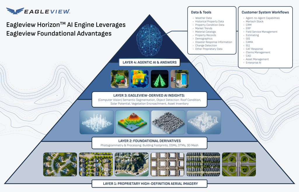
Eagleview Horizon, announced in April 2026, is the newest layer. The agentic GeoAI engine lets a user ask for properties in natural language, filter and score them, and export a result. A roofing team might request every old roof near last night's hail path. A claims manager might rank likely storm damage. A property manager might find aging exteriors across thousands of units. Eagleview says the system includes more than 20 tools and can connect to external agents through Model Context Protocol integrations.
The language is fashionable; the strategic logic is old. Own a scarce dataset, attach it to an expensive decision, then reduce the distance between question and action. Eagleview's advantage is not that it can place a chat box above a map. Competitors can do that. Its argument is that an answer grounded in proprietary, dated, high-resolution imagery and verified geometry deserves more trust than a generic model's guess.
Nearmap is the closest broad alternative in aerial property intelligence. Vexcel competes in high-resolution imagery. HOVER, Roofr, GAF QuickMeasure and RoofSnap challenge the measurement workflow from different angles. CoreLogic has deep insurance and property data; Maxar matters when satellite scale and global reach outrank street-level detail. Eagleview's 2026 settlement with Nearmap ended patent litigation dating to 2021 on confidential terms. Competition now returns to the product and the invoice.
What to copy - and when not to
Copy the wedge, not the fleet. Eagleview began with one dangerous task whose errors traveled downstream into labor, material and claims costs. It created a trusted artifact, fitted that artifact into existing systems, and only then expanded across adjacent decisions. The practical sequence is crisp:
| Move | What Eagleview did | What another company can copy |
|---|---|---|
| Find the costly chore | Replace ladder-based roof measurement. | Look for manual work where a small error creates a large bill later. |
| Create shared truth | Give contractor and insurer the same third-party geometry. | Build an artifact accepted by every side of the transaction. |
| Prove total economics | Connect accuracy to waste, cycle time and field visits. | Run matched tests and count downstream cost, not just software price. |
| Expand from the data | Reuse imagery for solar, government, utilities and disasters. | Sell new decisions from the same proprietary input. |
The model does not work everywhere. It weakens when imagery is missing or stale, a building is unusually complex, the decision requires an on-site condition that aerial capture cannot reveal, or a buyer only needs a rough estimate. It can also lose on economics when report volume is tiny, an insurer does not require a recognized provider, or a cheaper tool is accurate enough for a low-stakes job. Remote property intelligence reduces field work; it does not abolish the field.
Eagleview's culture language reflects the scale of that operation: “Do Big Things,” “Be Nimble,” “Keep Growing” and “Create Wildly Successful Customers” sit among six published values. Most U.S. roles are remote, while the work crosses software, flight operations, geospatial processing and customer workflows. The combination matters. This is a software company whose raw material still has to leave the runway.
EagleView launches remote aerial roof measurement.
The merger with Pictometry combines two complementary systems.
The OmniEarth acquisition adds automated data extraction.
Eagleview One unifies data, imagery and interactive 3D.
Horizon opens natural-language property analysis.
The birdhouse is still the best explanation of the company. It was cheap, close at hand and just realistic enough to test a difficult idea. The aircraft, private-equity owners and billion-image library came later. Eagleview's enduring playbook is less cinematic: measure the annoying thing, make the answer credible, and follow every customer who can use it.
Keep exploring