A city engineer clicks a water main on a map. The interesting part is not the blue line. It is everything the line can set in motion: identify the valves, tell field crews what to close, notify customer service, create a report, and leave an audit trail. VertiGIS lives in that unglamorous but valuable distance between seeing an asset and getting the job done.
The Victoria-rooted company makes enterprise geospatial software for organizations that own, operate, regulate, or document physical things. Its customers include utilities, telecom carriers, municipalities, airports, transport authorities, property managers, and environmental organizations. They already have maps, often built on Esri's ArcGIS. What they lack is a practical way to turn spatial data into the peculiar sequence of tasks their business requires.
VertiGIS sells that sequence. Studio builds web and mobile applications with less custom code. Networks models and maintains utility infrastructure. ConnectMaster keeps physical and logical telecom inventory straight. FM handles buildings, property, energy, green space, and maintenance. Land Management tackles cadastre and surveying. Integrator keeps the GIS record and systems such as SAP or Maximo from disagreeing about the same transformer.
A company assembled, not invented
VertiGIS does not have the neat garage mythology of a startup. Battery Ventures began assembling the platform in 2017, when it acquired Latitude Geographics, the Canadian maker of Geocortex. In 2019, four established specialists came together under the VertiGIS name: Latitude, Germany's AED-SICAD, Dynamic Design Group, and Geocom Group. The new business opened with more than 400 employees and 1,600 customers.
That origin explains both the advantage and the challenge. The advantage is accumulated domain knowledge. These teams knew how German cadastral systems differ from Australian council maps, how utilities document buried networks, and why a fiber operator cares about a logical circuit as much as a trench. The challenge is coherence. A catalog assembled through acquisition can easily become a collection of adjacent logos, contracts, and databases.
VertiGIS has kept buying depth: Swedish municipal software provider EDP in 2022, land-management specialist ibR in 2023, TOPO graphics in 2024, and 1Spatial in 2026. The last deal, valued at £87.1 million, is the most revealing. 1Spatial adds rules-based tools for validating and governing location data. VertiGIS had concentrated on the application layer - what users do with data. It bought further down the stack, where someone decides whether that data deserves to be trusted.

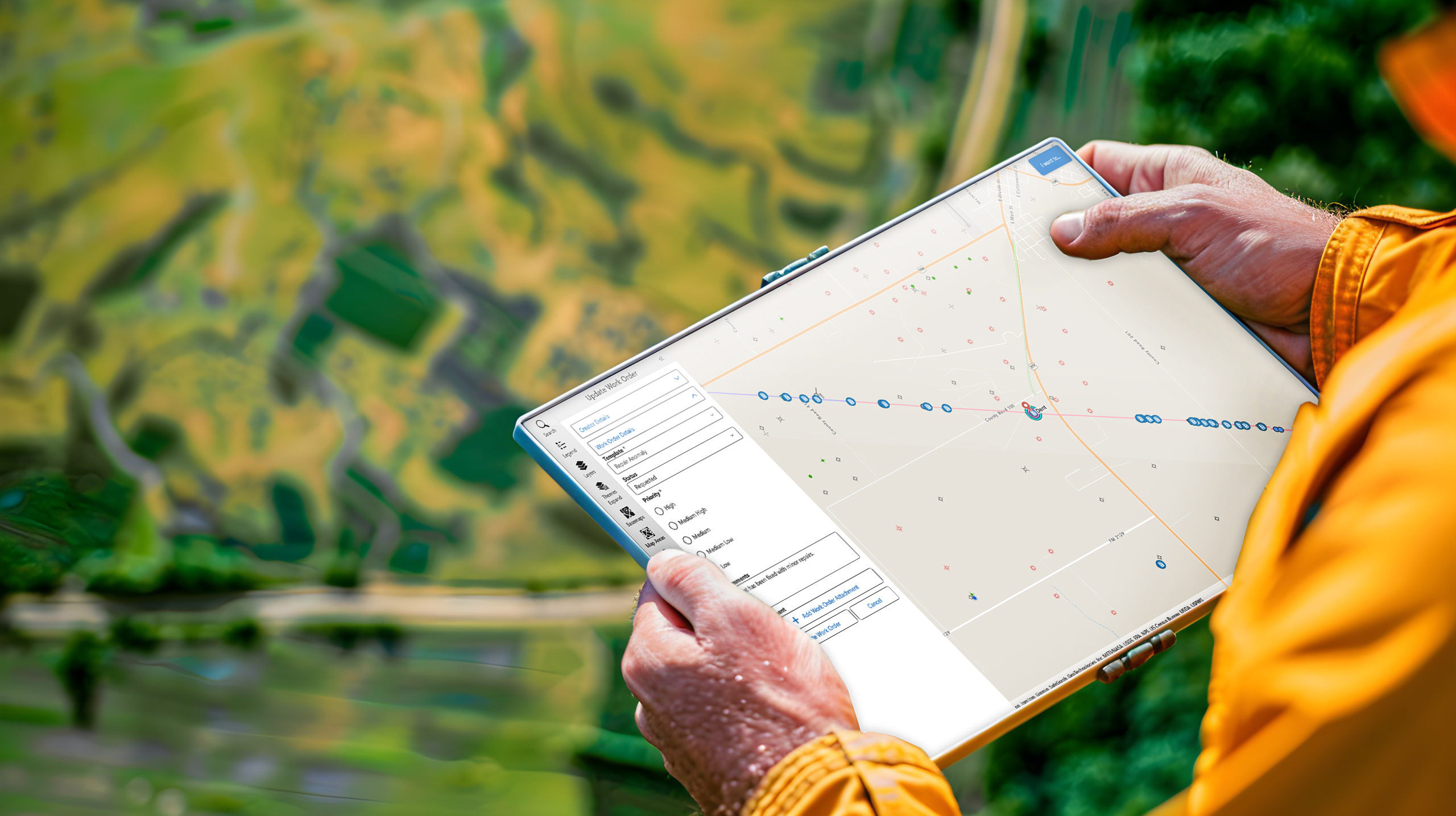
The product is what happens next
VertiGIS Studio is the easiest doorway into the strategy. The company calls it “clicks, not code.” Administrators can assemble applications, forms, searches, reports, print layouts, permissions, analytics, and guided workflows around ArcGIS data. A developer can still extend the software through public SDKs, but a GIS team does not need to commission a new application for every departmental request.
“The map is the interface, but the sale is the workflow.”YesPress analysis
Greenville Water offers the tidy proof. Its GIS team needed complex tools but did not want to hire consultants for every change or inherit custom code that outsiders would have to maintain. Using Studio, it reduced a water-off notification process from roughly seven minutes to about 30 seconds. Field operations and customer service could see the same work, which mattered as much as the stopwatch.
The National Trust used Studio to make a lifecycle tool for habitat work. Staff draw a polygon, classify the habitat and project stage, and roll the result into auditable progress toward a 25,000-hectare target. Singleton Council in Australia used it to replace a Geocortex environment while ArcGIS and an aging JavaScript API were changing underneath. Woolpert supplied licensing, training, support, and harder custom workflows while council staff handled more configuration themselves.
These cases reveal what failed first. It was rarely the underlying map. It was the brittle wrapper: browser plug-ins, an API headed for retirement, a custom viewer nobody wanted to rewrite, or a seven-minute chain of manual steps. What changed buyers' minds was not a prettier visualization. It was the prospect of preserving specialized behavior without preserving every line of old code.
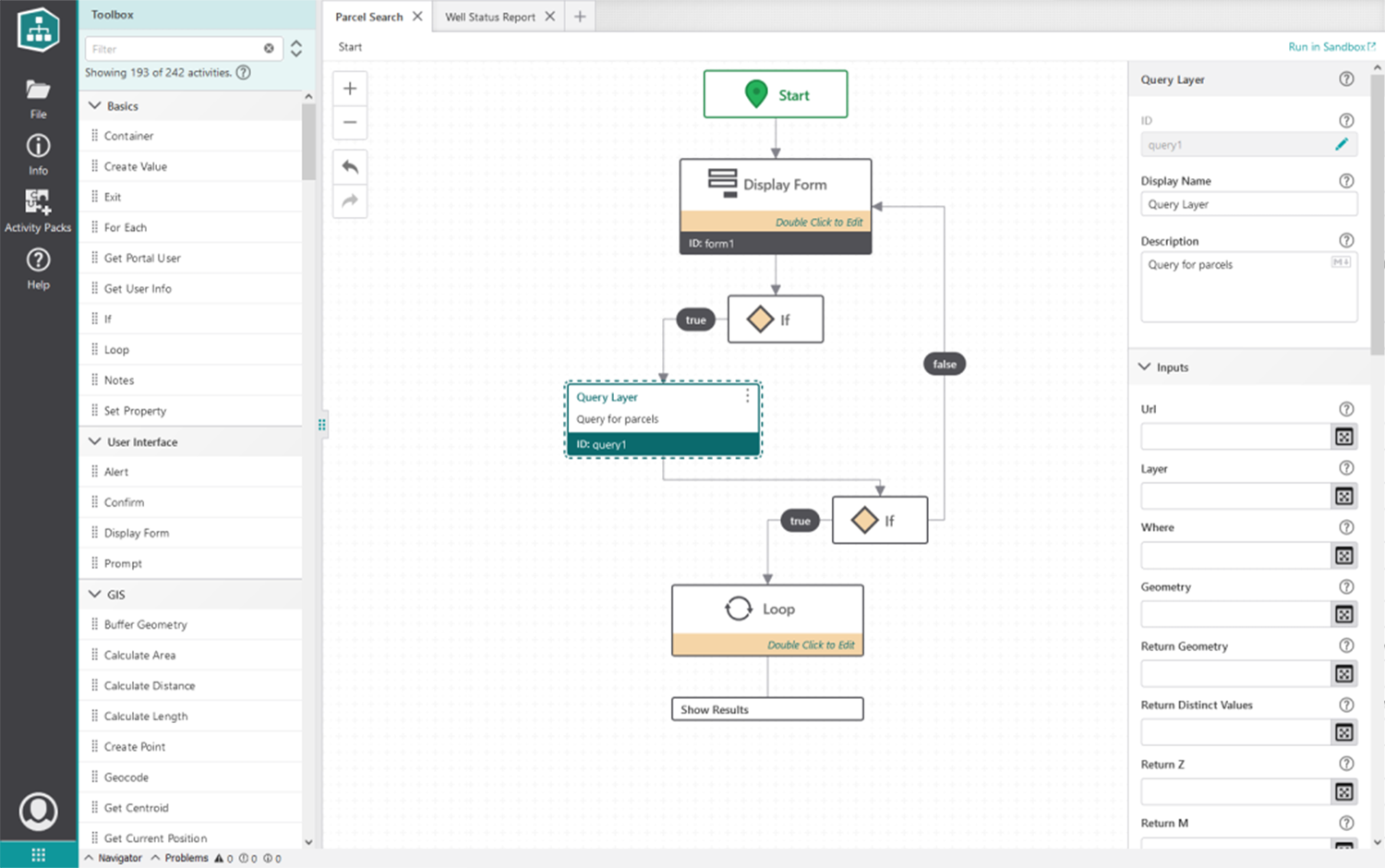
The reusable VertiGIS loop
Where the money comes from
There is no public $29-per-seat pricing card. VertiGIS Studio Web is licensed annually to an organization, either alone or in a bundle. The number of ArcGIS users determines the tier, and larger customers negotiate enterprise agreements. Desktop extensions can be licensed per seat. Studio Web has a 60-day trial, and VertiGIS says applications built during the trial are preserved when a customer buys.
The bill can also include implementation, customization, training, support, cloud hosting, and managed services. This is enterprise infrastructure software, bought by organizations whose migration plans are measured in systems and departments. The sticker price is only part of the cost. Internal configuration time, ArcGIS licensing, data cleanup, integrations, and change management matter too.
Public dollar prices are not posted. The disclosed model is annual, organization-level licensing with user tiers, bundles, per-seat desktop options, enterprise agreements, and service fees. Buyers need a quote and a total-cost model, not a shopping cart.
The dependence on Esri is central. VertiGIS calls itself the largest global Esri Platinum Partner and designs much of its portfolio to enhance ArcGIS rather than displace it. That makes adoption easier for Esri customers: the data model, identities, maps, and staff expertise are already present. It also means VertiGIS sits one layer above a powerful platform whose own products, including Experience Builder, can compete for some of the same budget.
Competitors change by department. IQGeo and GE Vernova's Smallworld chase utility and telecom networks. Hexagon and Bentley cover infrastructure. FME moves and transforms spatial data. IBM Maximo and SAP EAM own work orders and assets. Systems integrators offer custom ArcGIS applications. VertiGIS's answer is breadth around ArcGIS plus industry depth: configurable applications, network models, mobile work, facilities, land records, and enterprise integration from one vendor.
The Neo bet: cloud first, data before AI
VertiGIS Neo is not a single product. It is the company's attempt to make the portfolio feel like one modern direction: web-based, cloud-centric, mobile, industry-informed, and AI-enabled. Microsoft Azure is the production cloud for Neo, with a hybrid option for customers that want VertiGIS to run applications while they retain their own data storage. For sensitive German land records, a T-Systems partnership offers Open Telekom Cloud and a stronger data-sovereignty posture.
The AI claims are deliberately operational. VertiGIS describes checklist generation, document processing, natural-language application configuration, translation of master data, image-based asset recognition, and assistance inside workflows. The 1Spatial acquisition gives the pitch a needed foundation: predictions and agents are useless if a valve is mislocated, a parcel topology is broken, or two systems disagree about an asset identifier.
Still, buyers should separate what is available now from the larger Neo vision. A cloud architecture, a product philosophy, and a roadmap are not identical. “AI-enabled” also does not remove the slow work of defining rules, cleaning data, negotiating permissions, and getting crews to use a new process. VertiGIS can package the machinery. The customer still has to know how its operation should run.
What readers can copy
The most portable lesson is to build one layer above a dominant platform. Do not begin by replacing the map, ERP, or database. Find the ugly handoff where users export a spreadsheet, call another department, print a form, or wait for a consultant. Productize that handoff. Make the workflow configurable, keep an escape hatch for developers, and report an operational result a budget owner can understand.
The second lesson is to sell domain memory. A generic form builder can collect a field inspection. A vertical product knows the asset hierarchy, regulatory record, offline constraint, network rule, and approval chain around that inspection. VertiGIS has spent years buying companies partly because those details are expensive to relearn.
When the playbook works
- The customer already trusts a large platform.
- Workflows repeat across teams or regions.
- Spatial context changes the decision.
- Maintenance risk is worse than subscription cost.
When it does not
- The need is only a simple public map.
- The organization does not use ArcGIS.
- A tiny team cannot govern another platform.
- The workflow is unique, temporary, or still undefined.
VertiGIS occupies a useful middle: more packaged than bespoke GIS consulting, more specialized than a general map builder, and more spatially fluent than a conventional asset system. Its risk is the same as its strength. Breadth can turn into complexity, acquisitions can leave seams, and an Esri-centered strategy narrows the addressable buyer. But for an organization staring at a map of thousands of real assets and a folder of manual procedures, the pitch is admirably concrete: the map already knows where the work is. Now make it help do the work.