A blocked sewer is an expensive place to discover that your information does not join up. The pipe has a location, a history and a relationship with everything around it. Anglian Water used Esri technology to bring those clues together and decide where maintenance should happen next. In the first six months, the company reported a 51% reduction in blockages and more than £1 million in savings associated with fewer customer service issues. The map supplied the priorities. People still had to clear the pipes.
That last detail gets to the point of Esri UK. Geographic information systems, usually shortened to GIS, can produce beautiful maps. Their more consequential job is helping an organisation decide what to inspect, repair, build or protect. Esri UK supplies the software and expertise that turn location into something a business can act on.
in blockages
fewer service issues
Project results announced June 2023. These are reported benefits, not the project’s purchase price.
The map becomes a work list
Anglian Water’s starting problem was reactive, disconnected working. Its new risk tool brought factors such as pipe material, size, nearby watercourses and previous incidents into a mapped assessment. Staff could see where attention was most urgently needed. The June 2023 announcement also recorded 112 kilometres of sewers cleaned and eight tonnes of debris removed. Those are refreshingly physical outputs for a software project.
A companion customer case study describes a model using 15 risk factors, with results displayed through ArcGIS Online maps and dashboards. It also describes planned additions, including remote sensor information and machine learning. The distinction matters: a useful risk model can begin with existing asset and incident records. It need not wait for every pipe to become a connected device.
“With ArcGIS, we are able to display our data clearly and visually.”Laura Hinchcliffe
Geospatial Reporting Manager, Anglian Water
There is a copyable sequence here. Bring records together around an asset or location. Decide which combinations indicate risk. Give the resulting priorities to the people who schedule work. Record what they find. The technology becomes valuable when that loop changes a routine, rather than simply making the routine easier to illustrate.
One software family, a very British delivery business
Esri UK is the exclusive UK distributor of Esri’s ArcGIS system. The distinction between developer and distributor helps explain the company. It brings an established software family to British customers, then adds implementation work, support, training, data and products of its own. Its commercial role extends well beyond forwarding a licence key.
The legal history has a wrinkle. Companies House records incorporation in 1976 as Doric Gaines Limited, with that name ending in March 1994. Esri UK’s own account describes more than 30 years as the UK distributor. Treating the incorporation date as the birthday of today’s brand would flatten two different histories into one.
ArcGIS Pro is the desktop environment for mapping and analysis. ArcGIS Online provides an Esri-hosted service for creating and sharing geographic information. ArcGIS Enterprise gives organisations a deployment option in infrastructure they control. Around these sit specialist applications for fieldwork, reporting, development and other tasks. A customer can need several parts of the system without every employee needing the same tools.
Esri UK’s services catalogue reveals the practical business around that software: managed cloud environments, upgrades, health checks, backup and restore services, and maintained datasets. These address the less photogenic questions of enterprise computing. Who keeps the system running? Who handles a change? How does useful information stay useful after launch?
- 01CollectAssets + incidents
- 02ConnectA shared location
- 03PrioritiseRisk → work list
- 04ReturnFindings from the field
Illustrative workflow. The final step feeds the next decision.
Half a million assets, one airport
At Heathrow, the problem is partly the sheer number of things that must be understood together. A July 2026 announcement describes Heathrow Explorer bringing previously separated technical and operational information on more than 500,000 assets into a single view. The platform is intended to modernise workflows for 3,000 staff.
Its first live application, Winter Resilience, replaced printed-map workflows for snow clearance and de-icing with a shared picture on handheld devices. Managers can identify the nearest available clearance team and follow progress. Another application gives the fire services team information about water assets and live availability across a network that includes 72 miles of fire mains.
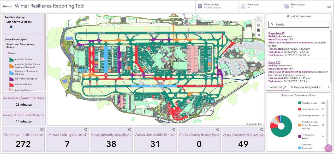
The interesting shift is in the audience. An airport map becomes an everyday working surface for teams with different responsibilities. They need information in the context of the place where they are acting. That gives location a practical advantage over a folder full of otherwise accurate documents.
Sweet catches the mistake while you make it
Esri UK also develops its own products. Sweet for ArcGIS is an editing application with configurable data-quality checks. It can enforce rules while users draw or alter geographic features, calculate values and give immediate feedback. Its appeal is easy to appreciate if you have ever inherited a dataset whose errors were discovered only after everyone had started using it.
The Sweet product page describes uses ranging from land data to electoral boundaries and police beats. Those examples share a problem: a boundary is more than a line on a screen. Changing it can affect other information and other people. Making checks part of the edit reduces the distance between a mistake and its discovery.
Maps+ tackles a different nuisance: preparing geographic data before anyone can analyse it. The service packages ready-to-use maps and features, drawing on organisations including Ordnance Survey, HM Land Registry and the Environment Agency. Customers buy access to maintained services, saving themselves some of the processing and publishing work. Esri UK’s local data knowledge is part of what it sells.
Field Maps closes another gap, between the office and the person standing beside an asset. Workers can use maps and forms to collect observations, find equipment and share updates. The application supports disconnected working too. That matters because the condition of a pipe, tree or building is established where it exists, not where the database administrator happens to be sitting.
The bill has more than one line
ArcGIS is a commercial system, and the buying decision starts with roles. Esri’s user-type model distinguishes people who view information from those who edit, work in the field, create content or perform advanced analysis. The six-type structure introduced in June 2024 ranges from Viewer to Professional Plus. Buying everyone the same capabilities would miss the point of that structure.
Subscriptions are only part of the calculation. ArcGIS Online uses service credits for certain activities, including storage, geocoding and drive-time analysis. Extra applications, premium data, training, implementation and managed services can add further costs. A sensible budget therefore starts with a proposed workflow and the people performing it, then counts the services that workflow consumes.
The reported Anglian Water savings belong on the benefits side of that calculation. They do not, by themselves, establish a payback period. Anyone assessing a similar purchase should compare the complete cost of operating it with a measured change in work: fewer repeat visits, shorter preparation time or better-targeted inspections. “We have a dashboard” is an awkward answer to a finance director’s question.
Why buy the surrounding system?
QGIS offers free, open-source GIS, including serious mapping and analytical capabilities. Its existence makes the competitive question useful. Esri UK’s proposition rests on the combination of software, shared applications, local data and delivery expertise. The choice depends on whether that combination addresses the customer’s requirements at an acceptable total cost.
For an isolated analytical task, a desktop tool may be sufficient. For an organisation distributing controlled information to many teams, the comparison must also consider administration, integrations, publishing and support. Existing skills and systems matter. A feature checklist alone will tell you little about who is going to maintain the finished service.
Frontier Agriculture illustrates a broader ambition. In December 2024 it announced a three-year managed cloud agreement with Esri UK, with plans to embed ArcGIS into existing applications, including MyFarm. Frontier’s customer base of more than 14,000 farmers represents potential reach, rather than a count of confirmed GIS users. The goal is to connect information across food production, extending beyond individual crop-mapping tasks.
Esri UK describes a culture centred on collaboration and customer success. Its careers material puts being a good colleague alongside technical ability. Read as an employer’s statement of intent, that fits a business where a successful project depends on specialists understanding how another organisation works. The expertise is partly geographic and partly the patient business of making a system usable.
A clearer map still needs an honest scorecard
There is a useful corrective to the opening success story. Anglian Water’s 2025 pollution incident reduction plan says that fewer blockages in 2024 did not translate into fewer pollution incidents, even though improvements appeared in other measures, such as flooding. This concerns a later reporting period and does not erase the earlier project results. It demonstrates why one favourable metric cannot stand in for the entire outcome.
GIS can organise evidence and direct attention. Results still depend on the quality of the records, the assumptions behind a risk assessment and the action that follows. A team that cannot maintain its data or act on its priorities has a different problem to solve before expecting a software purchase to change performance.
For prospective users, the practical starting point is modest: choose one recurring decision, establish its current cost or failure rate, and test whether geographic context improves it. Then track the result that actually matters. Esri UK’s most persuasive customer stories end with crews doing different work. The map earns its place when the work gets better.
Keep exploring
Visit Esri UK, browse its news and technical articles, or explore the product catalogue.
Watch the Anglian Water customer presentation and find demonstrations on Esri UK’s YouTube channel. Follow LinkedIn, X, Facebook and GitHub.