The most important thing INRIX sells is not traffic data. It sells permission to stop guessing. A state engineer can see which corridor collapses after a crash. A carmaker can warn a driver before brake lights appear around a bend. A delivery service can estimate arrival time without owning a map. A retailer can test whether a proposed site is near the people it hopes will visit. The common ingredient is movement - observed, cleaned, modeled and repackaged as a decision.
That sounds obvious in 2026, when a phone casually redraws a route before the driver notices a jam. It did not sound obvious in 2004. Traffic information came largely from roadside loops, cameras and, in the radio business, aircraft. Bryan Mistele and fellow Microsoft alumnus Craig Chapman built INRIX around predictive technology licensed from Microsoft Research and a cheekier premise: the vehicles on the road could describe the road.
The pitch failed before the product did
Mistele later said he expected fundraising to take a month. It took about a year and 70 rejections. Investors believed incumbents could crush the new company, or that the signal supply would never become dense enough. The first $6.1 million arrived in 2005 from August Capital and Venrock. A year later, INRIX's "Dust Network" combined anonymous position and speed reports from more than 500,000 commercial fleet, delivery and taxi vehicles with construction, incidents, weather, sporting events and school schedules.
This was the first practical trick: a slow car is not necessarily congestion. It may be a cautious driver, a taxi hunting an address or a vehicle waiting at a light. A credible traffic layer needs many observations, road context and machinery that discards outliers. INRIX's early Bayesian models fused those clues. The approach reached roads that governments had never wired, without requiring another sensor to be cut into the pavement.
“Venture capitalists all told us we would be crushed...now we are the leader.”Bryan Mistele, recalling the early fundraise
The economics changed with coverage. In 2007, INRIX said it had expanded real-time flow from 8,000 to more than 55,000 miles, signed more than 40 customers and recorded its first cash-flow-positive month. It raised $15 million anyway. Management's reasoning was simple: demand was arriving faster than a cautious plan could serve it. The company spent for international reach and more products instead of treating one positive month as the finish line.
A data company learns that nobody wants the data
For years INRIX's lineage was feeds and APIs - useful ingredients delivered to customers with the engineers to cook them. The company still licenses those feeds. But in 2020 it made a revealing admission: customers wanted answers to geospatial questions in a few clicks, not a pile of trillions of points and a new analytics department. INRIX IQ became the cloud storefront for that shift. At the time, SaaS represented about a third of company revenue, and management described applications and solutions as the future.
The portfolio now resembles a workshop more than a traffic app. Mission Control monitors a live road network. Roadway Analytics compares speed and travel time across corridors. Signal Analytics studies intersections. Safety tools look for risky conditions. Parking products estimate availability, restrictions, prices and charging options. Road Rules digitizes what is legal along streets and curbs. Trip products reveal origin-destination patterns. Ride Report, acquired in 2023, manages scooters, bikes, shared cars and delivery robots for more than 75 agencies across three continents.
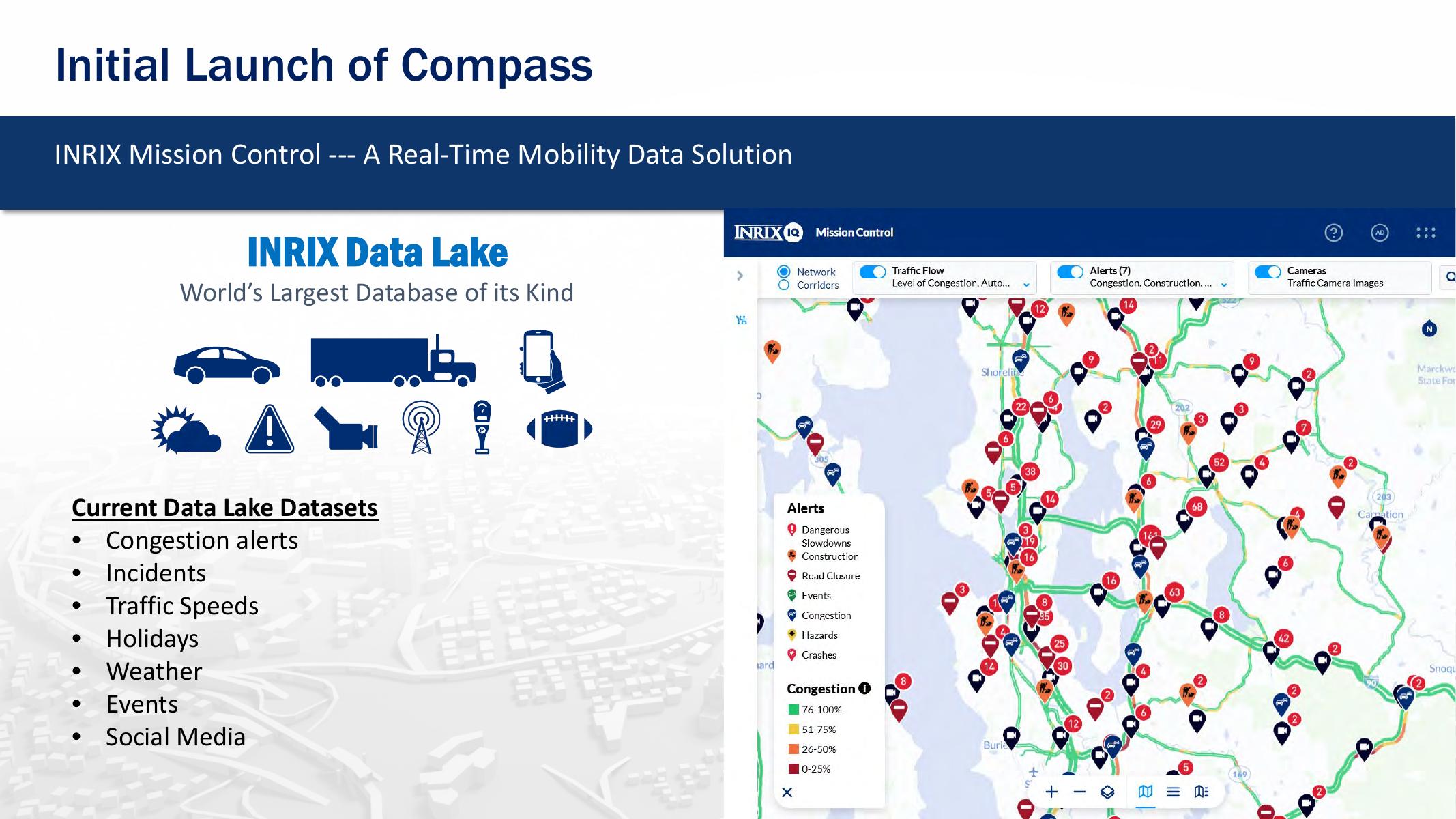
The same core asset is sold several ways. BMW used an INRIX parking route that did not merely choose the shortest path. It favored blocks with a higher probability of an open space, balancing driving time with the walk after parking. Transportation agencies use speed and incident data for operations, public messages and investment plans. Commercial users apply trip patterns to delivery, real estate, retail and finance. INRIX can be map-agnostic - attractive to a developer that wants traffic intelligence without adopting a rival's entire mapping stack.
What it costs, and what the invoice hides
There is no neat public price card. INRIX sells enterprise infrastructure, quoted by product, geography, road coverage and use. One useful window is Austin's procurement record: the city authorized $602,000 for a two-year INRIX traffic analytics data-services agreement beginning in December 2025. Older public proposals describe per-mile pricing. Neither number is a universal rate, but both correct the impression that this is a dashboard one buys with a corporate card.
The invoice pays for more than software seats. The durable cost sits under the interface: licensing signals, maintaining partnerships, normalizing different devices, mapping observations to road segments, measuring confidence and operating a large cloud pipeline. INRIX says its lake holds nearly 50 petabytes. Its current documentation describes a network involving 275 million vehicles and roughly five million miles of roads. Those are company-reported scale figures, best read as the size of the apparatus rather than a promise that every road is equally observed every minute.
The moat has potholes
INRIX competes most directly with HERE and TomTom, which also sell location platforms and traffic services. Google and Waze dominate consumer attention. StreetLight Data, Replica, Iteris and specialist vendors overlap in planning and operations. INRIX's position is narrower but useful: an independent mobility layer with deep traffic history, connected-car relationships and public-sector workflow products. It can complement a customer's map instead of demanding to be the map.
The model weakens when the probe panel is thin, late or unrepresentative. A 2026 transportation-data evaluation noted the effect when connected-vehicle provider Wejo ceased operating in 2023; Vermont used confidence scores to assess the loss within its INRIX-supplied information. That episode is the quiet dependency behind every magical traffic map. The colored line looks definitive. Underneath, it is an estimate assembled from partners that can change, fail or disappear.
When it will not work: sparse rural coverage, delayed feeds, biased vehicle samples, missing context or a customer unable to act. Data may reveal that an intersection is failing. It cannot obtain political approval, rewrite a signal plan or pour concrete.
Privacy is the other condition. INRIX describes its inputs as anonymous and aggregated; Ride Report emphasizes anonymization in shared-mobility programs. Still, trip data can reveal sensitive patterns if handled carelessly. Buyers need governance, retention limits and aggregation rules appropriate to their jurisdiction. A technically impressive origin-destination table is not automatically a socially acceptable one.
The copyable playbook
A founder cannot copy INRIX by scraping a few phones. The coverage loop took two decades: more signal partners improved the product; a better product won automakers and agencies; those relationships widened the signal pool. Acquisitions added missing dimensions - ITIS for European reach, ParkMe for parking, OpenCar for the dashboard and Ride Report for shared mobility. Capital mattered, including a $37 million Series D, strategic money from Porsche SE and Intel Capital, and $70 million from Morgan Stanley funds in 2023 that also refinanced debt.
But the operating logic is portable. Begin with an expensive decision, not a fashionable dataset. Combine independent signals because each one lies differently. Show uncertainty. Deliver the conclusion inside the buyer's daily workflow. Then turn custom analysis into a repeatable application. INRIX's move from raw feeds to IQ is a reminder that a data moat becomes more valuable when ordinary customers can cross it.
The company applies the same idea internally. Since 2022, its annual Innovation Week has paused regular work across departments. In 2025 employees submitted 47 ideas and completed 24 projects, with AWS staff joining teams. INRIX says 50 to 70 percent of past ideas have entered development pipelines. Those are self-reported figures, but the mechanism is specific: clear the calendar, mix functions, build in days, then create a path from demo to production. The follow-up idea - an Implementation Week - acknowledges the familiar corporate failure mode in which the prototype wins applause and then dies in a folder.
The next interface is a question
INRIX Compass places generative AI over the data lake using Amazon Bedrock. Instead of navigating layers and filters, a transportation professional can ask about a corridor, request likely causes and produce a visualization. It is a sensible interface for a product whose complexity has outgrown the patience of many users. It also raises the standard: a fluent explanation must preserve provenance, confidence and the difference between correlation and cause.
Recent work shows the company widening the aperture again. A Cleverciti integration adds computer-vision parking occupancy at the block and curb-segment level. World Cup reports turn event traffic into a public demonstration of the platform. The Signals Scorecard packages billions of connected-vehicle trips into intersection comparisons. Each is another attempt to move from “here are the dots” to “here is the choice.”
That is INRIX's durable idea. The road is not static infrastructure. It is a live system whose participants continuously report what it is doing. The company survived because that once-ridiculed premise became normal. Its future depends on a less romantic discipline: proving that one more layer, one more model and one more petabyte produces a decision worth the contract.