The iPad looked like a questionable idea. To ForeFlight’s founders, the tablet seemed large, and its purpose in their fledgling business was uncertain. Then they saw an approach plate load. A chart used to guide an instrument approach had found a screen big enough to make sense. The argument changed.
That small reversal tells you something about ForeFlight. Aviation was already rich in information. What pilots needed was a less awkward way to bring the right pieces together. A bigger screen gave the company room to work on that problem.
- A connected flight bag for planning, weather, charts and logging.
- Apple devices in the cockpit; web tools for planning and teams.
- Individual US subscriptions from $130 a year, with extras.
The chart that changed the argument
ForeFlight began in 2007, in the first iPhone’s orbit. Pilots Tyson Weihs and Jason Miller developed a weather-planning service; Adam Houghton helped launch the business. The first ForeFlight Mobile followed in 2008. By April 2010, the company had an iPad version ready when the tablets shipped.
The transition involved redesigning screens around the larger display, with weather at the center. The opportunity was practical: a pilot could inspect a route and the conditions around it without shuffling between many separate materials. The screen’s size, initially a question mark, became working space.
“First is important but first is fleeting.”Tyson Weihs · AOPA, 2015
Early enthusiasm also needed organization. As customer requests multiplied, informal conversations about desirable features gave way to a scoring system that weighed development effort and customer value. The original approach to choosing work had stopped fitting the volume of ideas. Growth required a better way to say yes.
One flight, fewer handoffs
Imagine the questions behind a routine cross-country flight. Which route? What weather? How much fuel? Which approach at the destination? ForeFlight Mobile brings those questions into a shared working environment on an iPad or iPhone. The pilot can plan, obtain a briefing, file, consult charts and later log the flight.
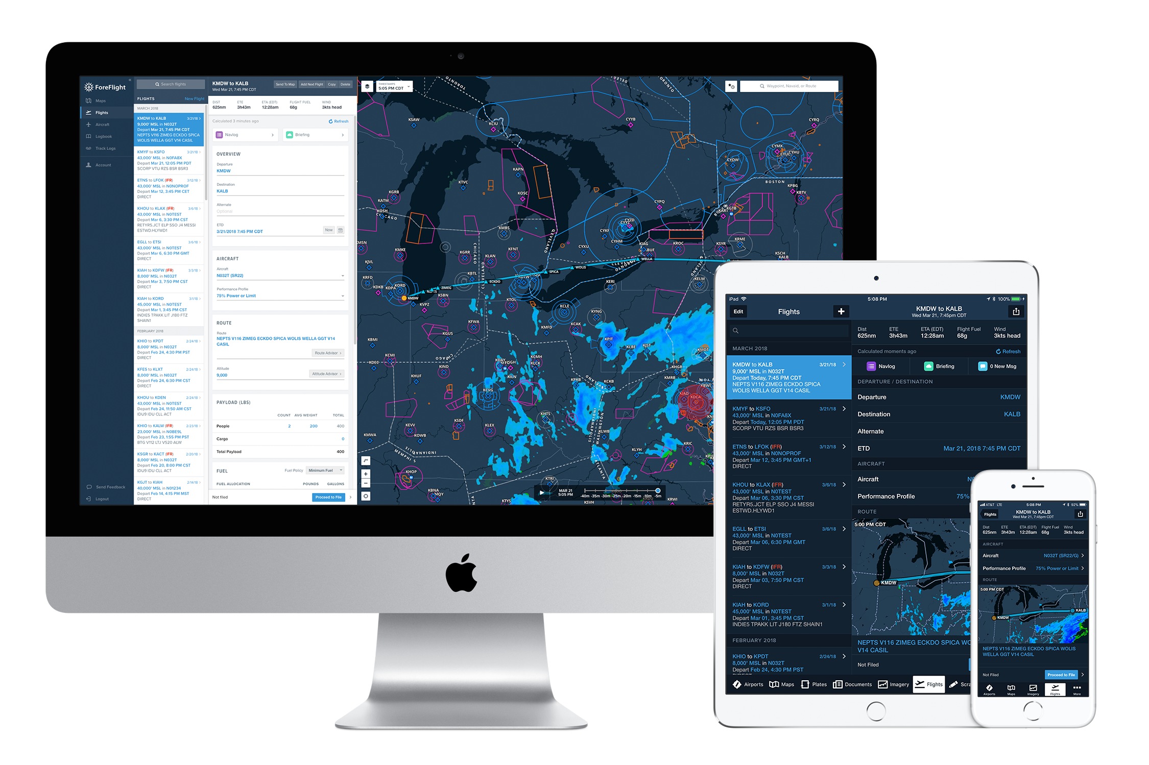
The interest lies in the relationships. A weather overlay means more when it sits beside the intended route. A terrain profile adds a vertical view to an overhead map. Aircraft performance data helps turn distance into estimates of time and fuel. Synthetic vision supplies a computer-generated view of the surrounding terrain.
These are aids to understanding, with capabilities that depend on the subscription, device and connected equipment. They do not remove the pilot’s responsibility to evaluate conditions. Even in 2010, Weihs described the iPad as a companion to the pilot, with primary navigation belonging to the aircraft’s avionics.
The app can also accept a customer’s own material. Content Packs bundle maps, waypoints, procedures and documents, allowing organizations to add information specific to their operations. That matters because a common application has to accommodate uncommon work: a backcountry strip, a company procedure or a particular patch of airspace. A standard interface becomes more useful when the operator can bring local knowledge into it.
The price of keeping the picture together
ForeFlight sells the workflow through annual subscriptions. At the published US individual prices, Starter costs $130, Essential $260 and Premium $390. The monthly figures on the pricing page are annual costs divided into twelve parts; the bill arrives annually.
Starter covers the basic planning and flying toolkit. Essential adds features such as georeferenced approaches, synthetic vision and hazard awareness. Premium adds prebuilt aircraft performance profiles, optimized routing and more detailed planning tools. One geographic region is included; optional chart packages, additional coverage and receivers can increase the total.
The customer might be a student, a weekend aircraft owner or a professional crew. Those people share tasks without sharing every requirement. The subscription ladder charges more as the planning becomes more demanding. Fleet and military customers have separate offerings.
Connected hardware is another part of the equation. The Sentry receivers, manufactured by uAvionix, feed supported weather and traffic information into ForeFlight. Reception and equipment determine what appears. ForeFlight’s own support material explains that an aircraft without ADS-B Out can have a limited traffic picture. A populated screen is useful; understanding what is absent is part of using it.
The flight bag grows a back office
ForeFlight’s expansion followed the work beyond the tablet. A 2017 alliance brought Jeppesen charts into the app. Boeing acquired ForeFlight in 2019. That October, Dispatch launched with Flexjet as a launch customer, connecting flight planners and crews through shared plans and documents.
Here the problem changes scale. One pilot needs a coherent flight bag; a department needs people working from the same plan. Dispatch connects scheduling inputs, planning and delivery to crew devices. Northern Jet says its adoption grew from a trial with a couple of airframes to fleet-wide use, including Dispatch and Runway Analysis.
Buying CloudAhoy in 2023 extended the business into post-flight analysis. September 2026’s ForeFlight Debrief release brought automatic flight segmentation, scoring and 3D playback to Essential subscribers and above. The workflow now reaches past landing, into reviewing what happened.
Ownership changed again in 2025. Thoma Bravo’s $10.55 billion transaction covered Jeppesen, ForeFlight, AerData and OzRunways assets. That figure belongs to the bundle. Jeppesen ForeFlight launched as a standalone company in November, bringing the chart heritage and mobile software under a shared identity.
Pack before you go
The limits are revealing. ForeFlight Mobile has no Android version; Garmin Pilot supports both Apple and Android devices. Compatibility, chart coverage and the aircraft’s installed equipment can decide the choice before interface preferences enter the conversation.
ForeFlight’s competitive case rests on how its tools fit together, supported by Jeppesen charts, aircraft data and connections to avionics. Garmin Pilot offers an overlapping collection of functions. For a buyer, the revealing comparison is a familiar trip: enter the aircraft, prepare the route, examine the weather and find the needed chart. The useful difference is whatever makes that work clearer.
Then there is the unglamorous question of downloads. Charts visible online are not necessarily stored for flight. ForeFlight’s Downloads settings establish regular coverage; Pack checks a planned route for additional material. Disabled chart types will not magically appear in Pack’s recommendations. The company suggests checking the result in Airplane Mode.
There is a useful lesson here for anyone building software: connect adjacent tasks, then test the connection under the customer’s actual conditions. ForeFlight’s insight was to give a pilot’s information a common place to meet. Making that place dependable still requires preparation, current data and a person who understands the flight.