The first thing Divirod sold was a sensor. It was an ingenious little listener: mount it above a reservoir, river, roof or shoreline and it could read navigation signals bouncing back from the surface. Water has a particular electromagnetic accent. Snow, ice and wet soil have their own. Divirod learned to translate the echoes into measurements.
The hardware worked. In its first commercial year, the Boulder company booked $175,000 selling devices. That is normally the part of a startup story where a founder orders more boxes. Javier Martí and Adam Wilson did the opposite. They got tired of selling hardware.
Their 2019 decision was the company-making one: Divirod would keep ownership of the equipment and sell the useful residue - measurements, dashboards, forecasts and alerts. The customer would not have to become a radio engineer, field technician, data plumber and hydrologist just to learn whether a road was about to flood. The sensor stopped being the product. It became the cost of admission.
One transaction. Customer owns deployment, upkeep, telemetry and the headache.
Divirod owns the sensing stack. Customer buys continuing intelligence as operating expense.
A divining rod with a PhD
Martí grew up in southern Spain, where a morning without enough water for a shower made scarcity less theoretical. His career wandered through telecommunications, the European space world and large Earth-science projects before he founded Divirod in 2016. The shift was personal and practical. Distant cosmic phenomena are fascinating; water reaches the balance sheet, the building and the person standing in the basement.
Divirod's GNSS reflectometry, or GNSS-R, is clever because it borrows rather than broadcasts. GPS and other navigation satellites already send signals toward Earth. A Divirod receiver listens to how those signals reflect from a surface. Its algorithms infer changes in water level, tides, agitation, snow accumulation, soil moisture and related conditions. The sensing is passive, low energy and designed to sit outside the water.
That above-water position is not merely elegant physics. Traditional equipment in a channel can become an expensive participant in the flood it is meant to measure. Logs, silt and debris are rude to instruments. A non-contact device mounted overhead has a better chance of continuing to report while the river is rearranging the furniture.
Divirod then mixes its readings with public gauges, historical records and customer data. This unglamorous harmonization may be as important as the sensor. Water records arrive in different units, cadences and standards, with awkward geographic holes. A brilliant model fed thin or incompatible observations remains a confident guess. Divirod's pitch is ground truth where customers need it, stitched into a broader picture they can query.
“I'm building the Google Maps of water.”Javier Martí, founder and CEO
Who pays to know the river's mood?
The buyers are organizations for which water is operational, not decorative: reservoir managers watching upstream conditions; local governments deciding when to close a road; factories protecting equipment; insurers estimating exposure; marinas tracking tides and agitation; property owners worrying about snow loading; researchers who need a cleaner data set. A dam operator may want a controlled release. An emergency manager may want a text message. A real-estate owner may simply want proof that the water crossed a defined threshold.
The product menu follows those jobs. Water Monitoring Services supplies managed instruments and dashboards. Water Risk Explorer gives analysts a cloud environment for current and historical data, multiple sources and model development. Early Flood Warning watches a location around the clock and sends threshold-based notifications. A Databricks Marketplace product launched in 2023 put US water levels and dynamic risk scores in front of data teams at more than 12,000 locations, with updates as often as every minute.
The commercial wrapper matters. Divirod describes an OPEX model rather than a large upfront equipment purchase. It manages the hardware, telemetry, maintenance and cloud system; the buyer pays for continuing access and service. Public pricing is not posted, so the honest answer to “what did it cost?” is: a quote, not a menu. The economic claim is total cost, not a cheap gadget - fewer custom integrations, fewer field visits, no repeater network in some remote deployments and one accountable vendor.
The customer is buying time
The cleanest proof is geographic. On San Giorgio Maggiore in Venice, sensors installed with Factum Foundation beginning in 2021 have tracked lagoon water, waves and wind around cultural heritage. In Madrid, Divirod worked with Canal de Isabel II on water-supply monitoring. A deployment in Rendsburg, Germany, involved Deutsche Telekom and the federal waterways authority. GHD reported a recreational-lake pilot in regional Victoria, Australia, accessible through a web or mobile dashboard.
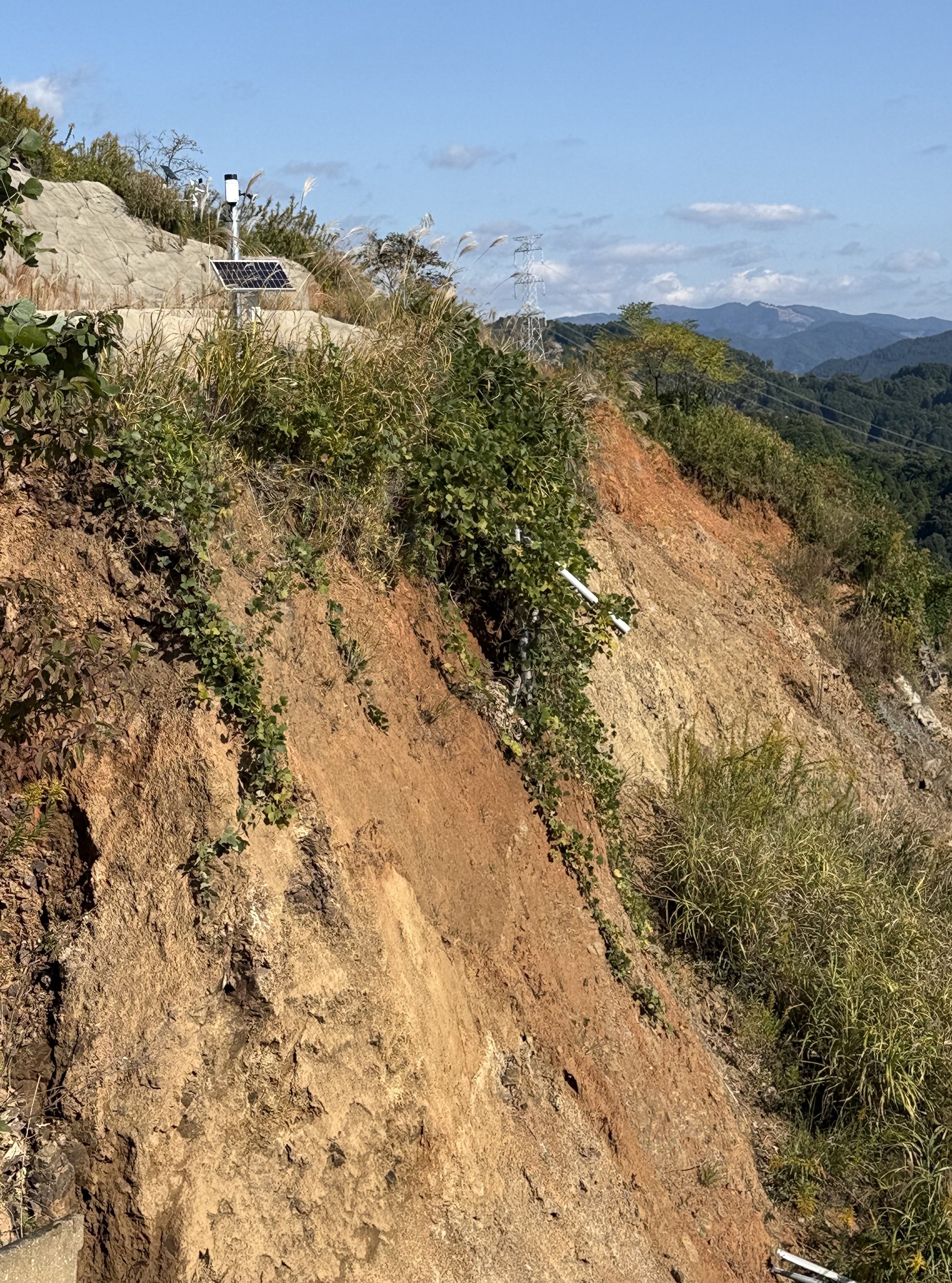
Then the technology climbed out of the water business. In a 2025 field demonstration with OKI in Japan's Fukuoka Prefecture, GNSS-R sensors monitored three landslide-prone areas. The system separated slope failures, slow creep and temporary changes associated with rain or ground moisture. During one August night, it registered a distinct terrain movement. Daylight photographs later showed the landslide, but the camera had not seen it happen in darkness. The receiver had.
That experiment points toward a broader environmental-intelligence company: water, terrain and the messy boundary between them. It also introduces discipline. A successful demonstration is not the same as a municipal warning network. Turning sensitive detection into a dependable alarm requires thresholds, false-positive management, communications, maintenance and somebody authorized to act.
What failed first - and what to steal
The first failure was commercial architecture. Hardware sales could produce revenue, but every device pushed operations onto the customer and reset the seller's relationship at checkout. Martí and Wilson concluded that data was more scalable. The pandemic then froze a planned seed round, giving the team an involuntary year to refine the new service. Later came a second hard lesson: adoption in climate tech moves slowly. Martí has said an early adopter once emerged from roughly every hundred conversations.
What changed their mind was not a laboratory disappointment. It was the friction of selling and the realization that customers wanted a decision, not an instrument. The copyable move is to find the annoying work surrounding your invention and absorb it. If buyers must install, calibrate, integrate, clean and interpret before getting value, the business may be hiding in that verb pile.
The second move is to fuse common data with scarce proprietary data. Public water records create breadth. Divirod's sensors add local fidelity where the map is blank. Each layer makes the other more useful. The third is distribution through credible partners: Databricks for data buyers, GHD for engineering reach, Deutsche Telekom for deployment, and OKI for disaster-prevention work in Japan. A nine-person company cannot knock on every utility door alone.
Good conditions
- An asset has real exposure to flood, drought, snow or terrain movement
- Existing observations are sparse, manual or unreliable
- A team can define thresholds and act on alerts
- Managed OPEX beats owning a custom sensor stack
Bad conditions
- An existing gauge already answers the operational question
- The site lacks a useful view, power or communications path
- Procurement cannot support a continuing service
- Nobody owns the response after an alarm arrives
This is where Divirod would not work: when measurement is mistaken for preparedness. A precise alert cannot move a vehicle, open a spillway or evacuate a neighborhood. It cannot fix a bad siting decision. If the buyer has no response plan, another decimal place is expensive theater. And if a simple public gauge already answers the question, a managed proprietary network may be unnecessary.
A patient market, whether founders like it or not
Divirod has raised about $7.6 million across disclosed seed, early-venture, bridge and convertible-note financings since 2021. Its backers include Thin Line Capital, GoHub Ventures, TDK Ventures and GHD. The dollars are modest beside the infrastructure the company hopes to influence. That mismatch explains both the partner strategy and the service model: borrow satellite signals, build compact sensors, use established channels and make each deployment feed a larger data platform.
The company is still small, and its founder is unusually plain about the market's pace. Water risk is obvious; budget ownership is not. A utility, insurer, property operator and emergency office may all benefit, yet each buys differently. Climate adaptation can live in the organizational crack between “important” and “this year's purchase order.”
Divirod's useful insight is that uncertainty itself has a cost. A false alarm shuts a road for nothing. A missed flood damages equipment. An unnoticed leak wastes inventory. The platform does not sell certainty - water would laugh at that - but it can sell a more current picture and a few additional hours in which to choose.
The sensor on the Japanese hillside looks almost comic against the mountain: a short pole, a small solar panel, no grand machinery. That scale contrast is the business in one frame. Divirod is trying to make a vast, unruly physical system legible through many small listeners, then charge for the translation. It began by selling the ears. The bet now is that the world will pay for what they hear.