A bridge can be perfectly visible and administratively invisible. You can point to the concrete, drive to the site, perhaps even photograph the workers. Yet the person authorizing the next payment may still need a measurement, an inspection record, a milestone report, and a document sitting somewhere else. CyberSWIFT has built a business around bringing those pieces together. The map provides the address. The software supplies the unfinished business.
- Maps meet management: land records, construction progress, and CSR programs.
- Field evidence travels with the work: geotagged photographs, documents, and mobile inspections.
- Customers include public departments and companies with complicated physical assets.
- The buying decision involves implementation, integration, and data collection as well as software.
01 Five thousand people, one chain of decisions
Since 2016, CyberSWIFT has worked with West Bengal’s Public Works Department on Samiksha, a system for monitoring roads, buildings, and bridges. Its published case study reports more than 5,000 departmental users, from junior engineers to the principal secretary. That is an unusually useful way to understand the company: follow a piece of information as it climbs an organization.
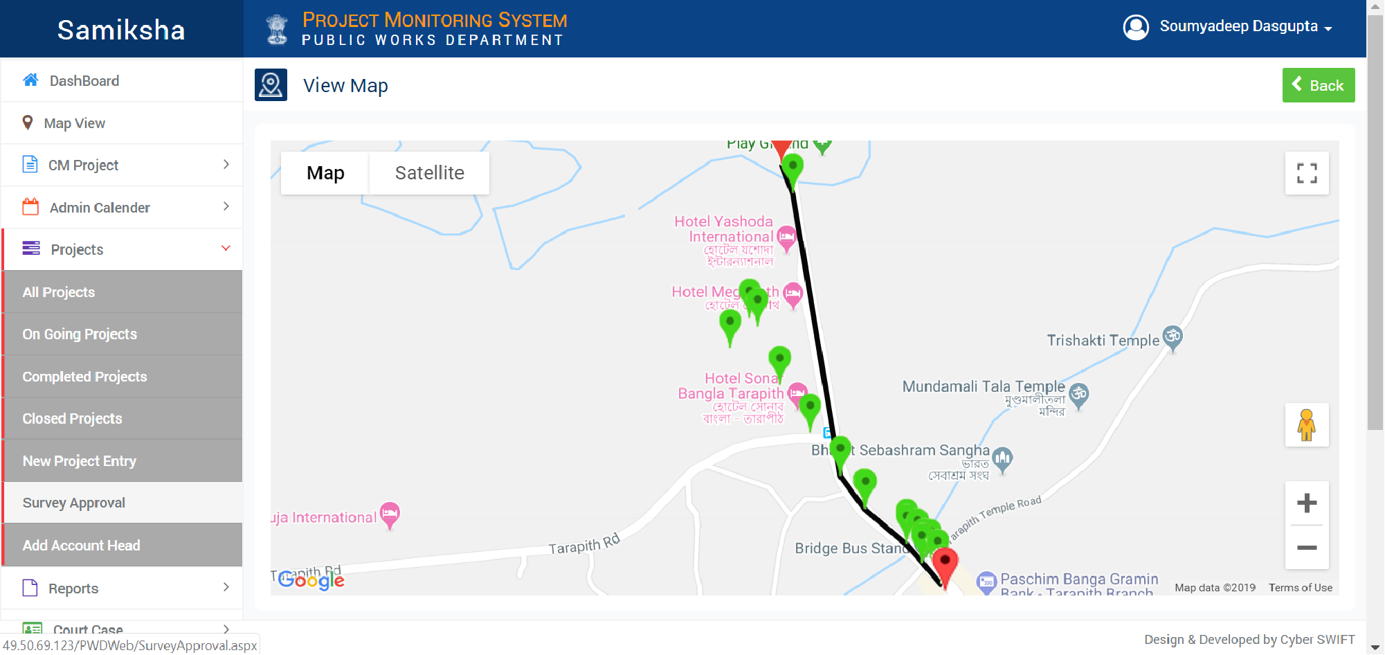
Samiksha links administrative approvals, project milestones, geotagged photographs and videos, fund requisitions, reports, and court cases. An inspection becomes evidence attached to a project; a request for funds can sit beside progress against a milestone. CyberSWIFT reports that the department received a SKOCH e-Governance award in 2019 for implementing the system. The achievement belongs to a departmental implementation, with CyberSWIFT supplying the technology.
Reported in CyberSWIFT’s Samiksha case study. One implementation, rather than a company-wide user total.
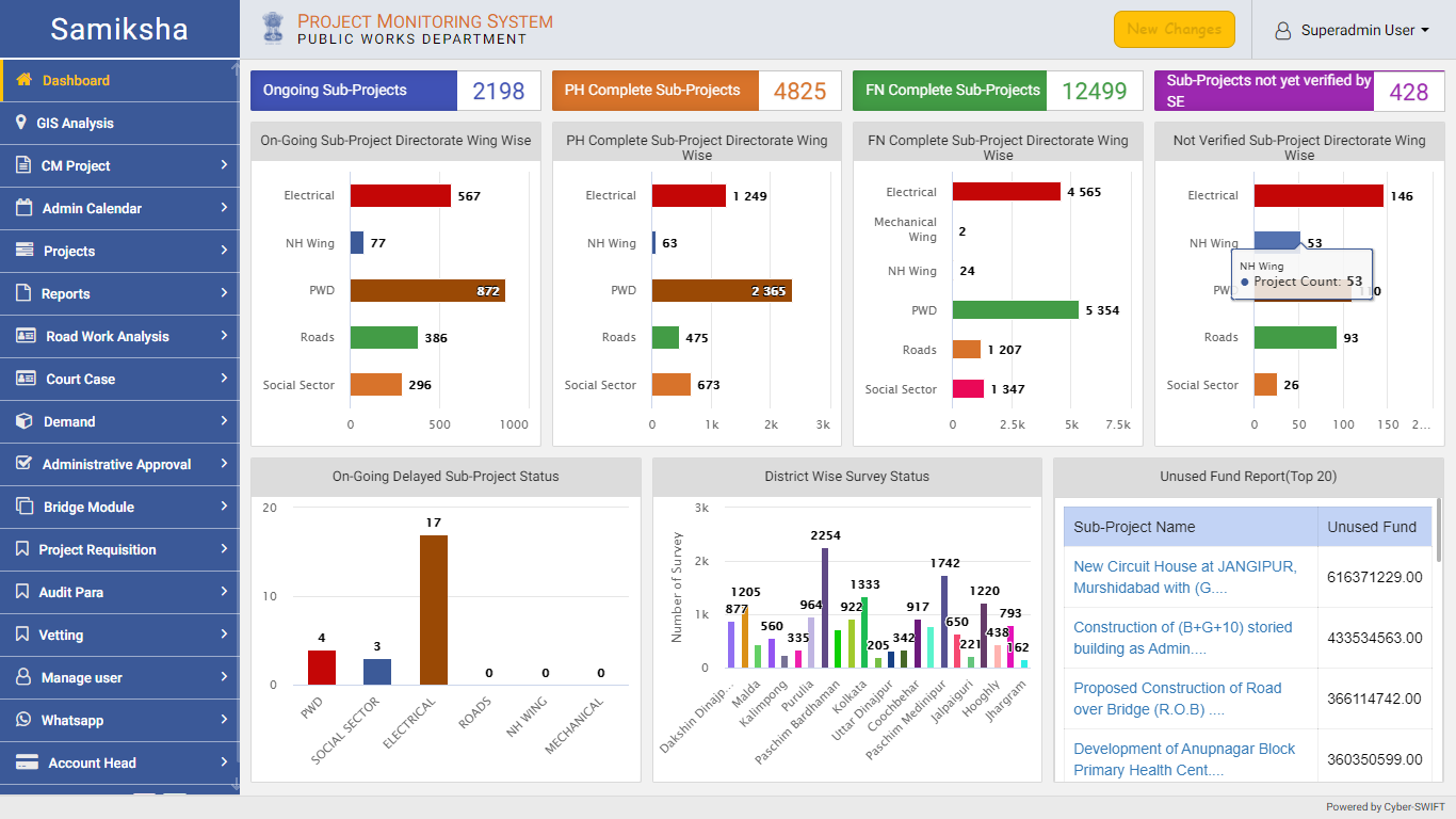
The broader product behind this kind of work is PPMS, its Project Progress Monitoring System. It combines geographic information with management records and includes an electronic measurement book, a site inspection app, and financial progress tracking. The app can store information offline. Anyone designing for a construction site should linger over that detail: the reporting process must survive the place where the work actually happens.
A field official records geotagged photographs and videos. PPMS supports offline storage when a connection is unavailable.
02 The brothers and the stubborn ground
Paresh Patel and his brother Kishore founded CyberSWIFT in 1997. Its history includes an early concentration on eastern and northeastern India and an expansion across India in 2018, described in a published founder profile as following the company’s growth strategy and client relationships. The origin has less of the immaculate business-school plan about it than the subsequent product catalogue suggests.
“Data collection from difficult geographic areas was particularly challenging.”Paresh Patel / The CEO Magazine
That recollection gets to the stubborn part of geospatial work. Before a useful map exists, somebody has to obtain useful records of the ground. CyberSWIFT offers surveys, map digitization, remote sensing, photogrammetry, and GIS development. Collecting and structuring the data belongs in the same conversation as designing the application. A handsome interface has limited influence over a missing boundary.

Today, the company combines US management with Indian development operations. Its current global site identifies Kishore as CEO and Nanda Nair as president; the Indian site identifies Paresh as CEO of CyberSWIFT Infotech. The distinction matters to a buyer arranging supervision and delivery across countries. CyberSWIFT sells that arrangement as a way to combine local project management with development capacity in India.
03 Every parcel has a past
Land is where the company’s proposition becomes especially concrete. LAMS, the Land Acquisition & Management System, attaches ownership, documents, compensation, litigation, and acquisition stages to plots. A boundary supplies the shape of the problem. The surrounding records explain why an organization might struggle to act on it.
For Tata Steel, CyberSWIFT describes a web and mobile platform bringing together land information and rehabilitation and resettlement proceedings across locations. Its features include digitized cadastral and revenue maps, acquisition status, grievances, and records of affected families. Compensation, employment, training, and supporting documents appear alongside the geography. The important unit of information can be a household as well as a parcel.
For Olayan Real Estate Management Company, the requirement was a central land and asset repository: select a plot and retrieve the associated records. CyberSWIFT describes map layers, satellite imagery, access restrictions, and legal information. The practical appeal is straightforward. A portfolio becomes easier to inspect when its documents have a place to live.
KINFRA, Kerala’s industrial infrastructure agency, offers another variation. CyberSWIFT’s published case study describes an online land allotment portal with applications, payments, approval flows, document storage, and notifications. An Android app lets officials demarcate plots. Here, GIS sits inside a transaction: an applicant wants land, officials need to review the request, and the system must keep the steps connected.
04 The same question, asked of a CSR budget
TechCSR applies a similar approach to corporate social responsibility. It combines budgets, project tracking, NGO due diligence, beneficiary assessments, and location analysis. Its mobile tools capture field activities, and its mapping functions show where beneficiaries and projects are located. The company publishes testimonials from Cipla and Reliance Foundation about its CSR work.
The editorial inference is simple: an expenditure and an activity record become easier to interrogate when you can see where they belong. A CSR team can examine a project’s documents, spending, and beneficiary information together. The software creates a structure for assessing impact; the quality of that assessment still depends on what gets measured and entered.
05 Buying the work behind the screen
CyberSWIFT occupies the space between a GIS specialist and an enterprise software consultancy. It offers Salesforce, Snowflake, NetSuite, custom web and mobile work, integration, and migration alongside mapping. A customer can commission a domain application or bring in developers to help an existing team. Its engagement options include fixed cost, time and materials, and dedicated resources.
- Fixed cost
- Agree a defined scope and price.
- Time & materials
- Pay for the work performed as requirements develop.
- Dedicated resources
- Contract capacity for the team and task.
Engagement models advertised by CyberSWIFT. Scope, integration, and fieldwork shape the project budget.
Its partner page lists relationships with Esri, EnterpriseDB, Trimble, Hexagon, Dell, HPE, and Microsoft, spanning mapping platforms, databases, survey instruments, and infrastructure. These relationships help explain the combination of services. CyberSWIFT can work with existing platforms and the equipment used to create their data, rather than requiring every client to adopt one proprietary mapping environment.
The alternatives are other GIS integrators, software consultancies, or an internal team assembling the same functions. Esri also supplies a platform CyberSWIFT uses, so treating it simply as a rival would obscure the market. The meaningful comparison is who will deliver the whole job: collect records, reconcile them, build workflows, integrate systems, and maintain the result.
A company-published Localligence testimonial dates the relationship to 2009 and describes three previous suppliers that struggled with its pace and standards. It is a useful buyer’s complaint, though one testimonial cannot settle a vendor comparison. Ask for evidence from work resembling your own, including what happened when requirements changed.
06 Start with the next decision
By August 2026, CyberSWIFT’s blog was discussing road condition monitoring through AI, GIS, mobile collection, and video analytics. The vocabulary has changed; the recurring concern is recognizable. Capture evidence from physical assets and make it available to the people responsible for deciding what happens next.
There is a method here that a reader can copy. Pick one consequential decision: release a payment, resolve a grievance, inspect a delayed project. Establish which location it concerns, what evidence it requires, who owns the next action, and how the record will stay current. Then evaluate the software against that chain. This is an interpretation of CyberSWIFT’s project designs, rather than a promise of their results.
It also sets the conditions for a useful implementation. Inconsistent field updates, disputed records, or an approval with no accountable owner can leave a map beautifully informed about yesterday. The buyer must budget for those organizational tasks alongside development. CyberSWIFT’s most interesting proposition is the attempt to join them: a picture of the ground with enough administrative memory to make the next decision possible.
Follow the work
Explore CyberSWIFT, LAMS, PPMS, and TechCSR. Read the company blog and the Columbus Chamber spotlight.