Thirty-nine days is long enough for a data job to acquire a personality. At GeoPostcodes, a company supplying postal and administrative geography, that was roughly how long a population-data update took. The task sounded modest: work out how many people lived inside particular boundaries. The computer had a less modest opinion.
The old workflow combined PostGIS with a headless QGIS installation. Population arrived as a grid; postal areas arrived as shapes. Matching the two at global scale kept the database working at capacity. Wherobots helped distribute the work, bringing the refresh into hours. GeoPostcodes now describes the reduction as 39 days to less than one day. Geography had not become simpler. The machinery had become better suited to it.
- Wherobots runs spatial analytics and imagery workflows using SQL and Python.
- Its founders created Apache Sedona before starting the company in 2022.
- Customers include GeoPostcodes, Overture Maps Foundation and AddressCloud.
- The useful question is whether faster processing changes what your team can deliver.
01 / A map hides a difficult join
Consider an insurer asking which properties sit inside a flood zone. A conventional database joins rows using a shared identifier. A spatial database may need to calculate whether one shape intersects another. Add millions of properties, detailed hazard boundaries and imagery, and the innocent word “inside” becomes a considerable amount of work.
Wherobots serves the people doing that work: data engineers, analysts and machine-learning teams. Its managed cloud platform combines spatial computation with notebooks, APIs and production jobs. Vector data describes points, lines and polygons. Raster data describes grids of pixels, including satellite imagery. The attraction is being able to use both in a data workflow without assembling a procession of specialist systems.
For GeoPostcodes, the practical changes included tiling the population raster, reading required pixels and partitioning boundary data so joins and aggregations could run in parallel. That is a useful lesson to copy: examine how work is divided and how much data is read before concluding that the answer is simply a larger machine.
Customer-reported population-data refresh. The second bar marks the one-day upper bound; results depend on workload.
02 / The researchers arrived before the startup
Mo Sarwat and Jia Yu came to this problem through research at Arizona State University. Their project, originally called GeoSpark, extended large-scale computing systems to handle spatial data. It became Apache Sedona. Wherobots’s history dates GeoSpark’s first release to 2017 and Sedona’s entry into Apache to 2020.
In June 2022, they founded Wherobots. Sarwat became CEO; Yu became chief architect. The sequence matters. They had already spent years working on the uncomfortable meeting between geometry and distributed computation. The commercial company could build on code and developer habits that existed before its sales pitch.


That research received a conspicuously patient form of recognition. In November 2025, a paper they co-authored, “A Cluster Computing Framework for Processing Large-Scale Spatial Data,” received the ACM SIGSPATIAL 10-Year Impact Award. A decade is a rather more demanding review period than a launch week.
03 / Billions of buildings, familiar code
The Overture Maps Foundation provides a different test of the proposition. In Wherobots’s November 2024 account, Overture’s building dataset contained 2.3 billion geometries and required frequent updates. Jennings Anderson, then described as an Overture geoscientist and Meta data engineer, reported acceleration of up to 20 times after moving its production pipelines to Wherobots.
“We accelerated the pipelines that produce the buildings dataset by up to 20x”Jennings Anderson, quoted in November 2024
His account also described a simple code redirection and retained Apache Sedona compatibility. A faster engine is easier to adopt when it accepts work people have already written. WherobotsDB, the company’s distributed compute engine, makes that compatibility central to its offer.
AddressCloud supplies another concrete use: property-level flood and fire information for insurers. Its engineer John Powell described operations that previously took hours or days completing in minutes, and highlighted combined vector and raster analysis. These are customer reports about particular workloads. They give a prospective buyer useful questions for a trial, rather than a universal stopwatch.
04 / The cloud company that also fits on a laptop
The product names need a moment’s attention. Wherobots’s early commercial platform used the SedonaDB name. In September 2025, the Apache Sedona community introduced a separate open-source, single-node analytical engine called SedonaDB. The current managed distributed engine is WherobotsDB. Similar names, different jobs.
The newer SedonaDB is written in Rust using Apache Arrow and DataFusion. It is intended for a laptop or a single virtual machine. Its announcement explicitly recognizes that distributed systems are unnecessary for some workloads and can add unwanted cost and complexity during development. That is a sensible admission from a company selling managed compute.
By March 2026, Wherobots described a Rust-native, Arrow-columnar execution layer for WherobotsDB, with SedonaDB performing spatial logic and GeoArrow-based geometry handling reducing data-copying overhead. The same ecosystem now reaches from local experimentation to managed distributed execution.
05 / A satellite photograph becomes a table
RasterFlow extends the proposition into imagery. Announced in private preview in December 2025 and opened in public preview in September 2026, it prepares image mosaics, runs computer-vision models and turns results into georeferenced outputs. A team can use a supplied model or bring its own.
The visible result might be a set of roof polygons, agricultural field boundaries or tree-canopy estimates. Underneath sit the less photogenic chores: preparing inputs, dividing imagery into patches, running inference and assembling outputs. Those chores are substantial enough to be a product.
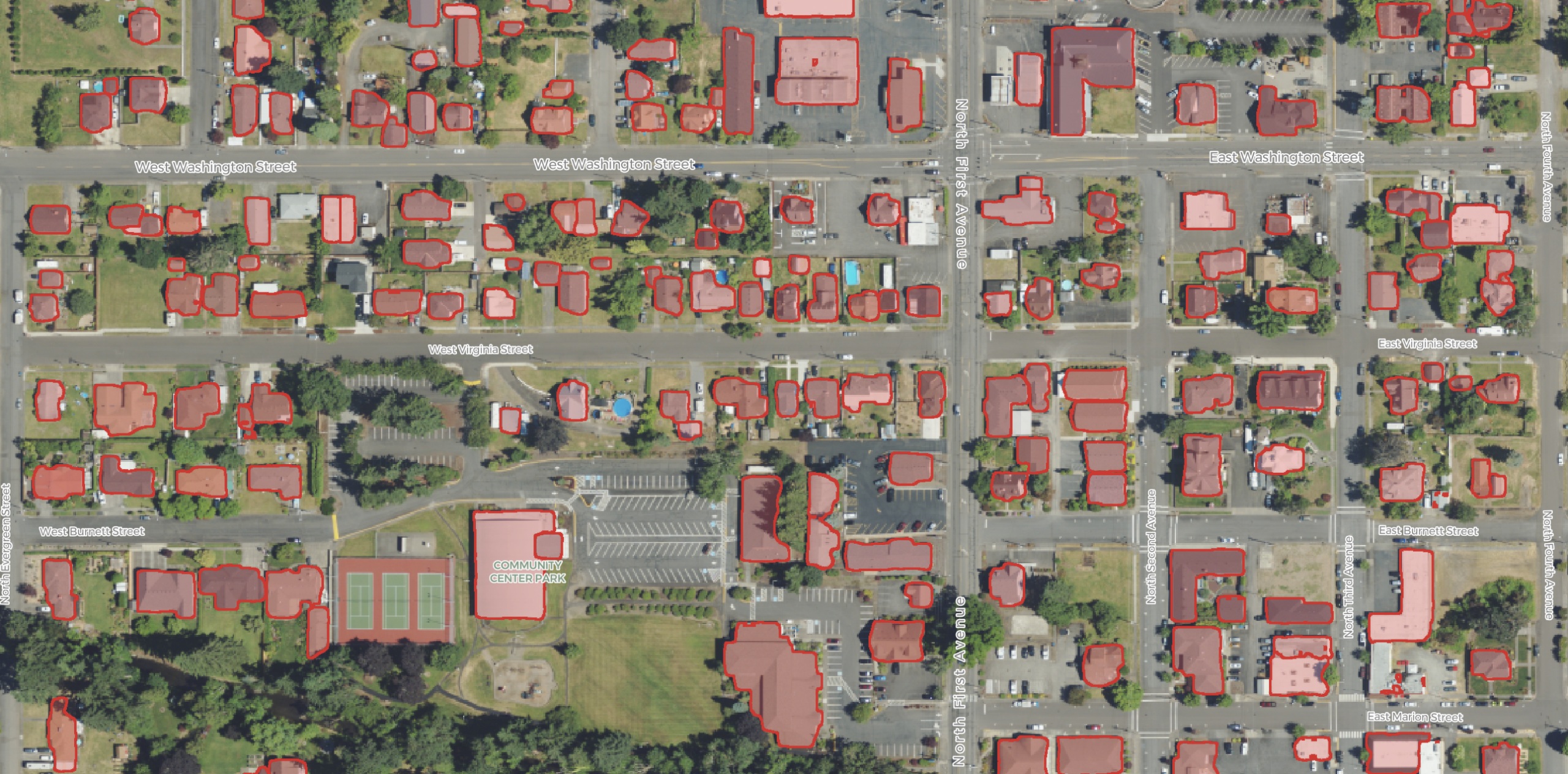
A May 2026 Wherobots example produced roughly 312,000 roof detections within a larger Marion County, Oregon, imagery run. Its next step was to compare them with Overture building footprints. That follow-up is the interesting part. A model output becomes useful after someone checks whether it agrees with an appropriate reference.
In a September 30 technical article, Wherobots explained how RasterFlow overlaps uploads, model execution and downloads using NVIDIA GPUs and CUDA streams. While one batch is being processed, the next can be arriving and the previous one leaving. Keeping expensive hardware occupied is another version of the original lesson: arrange the work properly.
06 / What the bill measures
Wherobots charges for consumption in Spatial Units. Its October 2026 pricing page advertises a Professional trial with up to $95 in usage, followed by $95 per month in prepaid credits. Innovation engagements start at $3,000 per month with an annual commitment; Enterprise terms depend on scale. Buying through AWS Marketplace is also available.
Detect solar panels across 500 km² using 30 cm NAIP imagery, four bands and one time period.
Illustrative September 2026 task estimate, rather than a full deployment budget. Preview prices may change.
RasterFlow’s pricing counts data volume, with task-specific rates and complexity factors. Finer resolution, more spectral bands and more observation periods increase the volume. The quoted example is useful because its assumptions are visible. A real budget should also account for the team’s storage, integration and validation work.
The business has attracted venture funding: a $5.5 million seed round announced in June 2023, followed by a $21.5 million Series A announced in November 2024. Felicis led the latter, alongside Wing Venture Capital, Clear Ventures, JetBlue Ventures and Prosperity7. The disclosed rounds explain the capital behind the company; the customer workloads explain the purchase.
07 / Leave the data where the customer keeps it
Wherobots competes with several different habits. Teams may use PostGIS, DuckDB Spatial or GeoPandas; others build on general-purpose cloud engines or Google Earth Engine. The relevant comparison depends on dataset size, operations and existing infrastructure. A local analysis that already finishes quickly may have little reason to acquire a distributed runtime.
Its integration strategy is especially practical. The September 2025 Unity Catalog connection lets Databricks customers process existing lakehouse data through Wherobots. Amazon S3 integration serves teams keeping data in object storage. Havasu began as a spatial extension to Apache Iceberg; Wherobots also contributed to standard geospatial types in Iceberg and Parquet. Open formats make the results easier to carry into other systems.
The February 2026 partnership with Felt addresses the next handoff: turning computed spatial data into interactive maps for people making decisions. The announcement specifies Felt Enterprise and Wherobots Professional for the connection. Producing the answer and putting it in someone’s hands are separate pieces of a workflow.
Before committing, a team can copy the discipline visible in these examples: choose a real bottleneck, preserve the existing code where possible, test a representative area, measure cost as well as runtime, and inspect the result. During public preview, RasterFlow’s listed region is AWS Oregon. A deployment with incompatible residency requirements needs a different arrangement.
The point of removing a 39-day wait is that a team can ask its next question sooner. GeoPostcodes’s pipeline is a good introduction to Wherobots because the improvement is legible. A month-long computation becomes something that fits inside a working day. Suddenly there is time to find out whether the question was the right one.
Keep exploring
Products, practical walkthroughs and the people building them.