A ship switches off its identification signal. On a tracking screen, the silence might resemble an empty patch of water. In the ocean, of course, the ship is still there. That small difference between a missing report and a missing object is a useful way into General Atomics Intelligence, a company whose work begins where a tidy map stops being trustworthy.
- The job: connect observations from different sensors to understand what is moving, where, and why.
- The tools: Optix for data management and analysis; GeoMesa for open-source geospatial infrastructure.
- The stakes: maritime monitoring, intelligence analysis and aircraft command and control.
A beacon is only one witness
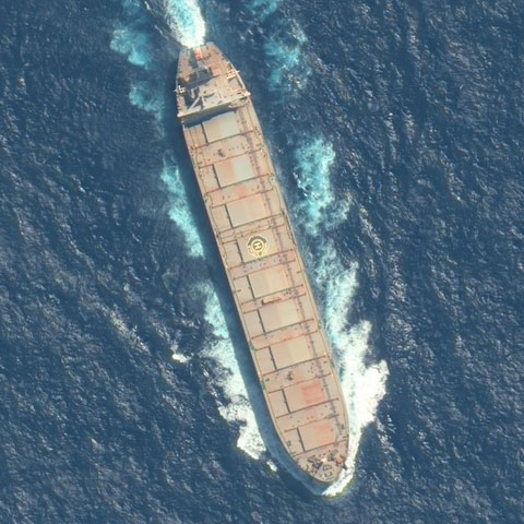
In a 2023 case study, the company paired its Optix platform with Maxar satellite imagery. Vessel broadcasts supplied one account of activity in the East China Sea; pictures supplied another. One photographed vessel corresponded to a transmitting fishing boat. Another had no matching vessel broadcast. Nearby, signals from fishing nets appeared in a characteristic pattern. The analysts interpreted the second ship as likely operating without transmitting AIS, the Automatic Identification System.
The qualifier matters. This was an interpretation assembled from evidence. A broadcast could be absent or misleading; an image could add context. The useful question became whether independent observations agreed about the same place and time. For someone monitoring maritime activity, Optix offered a way to investigate that disagreement.
The map has a plumbing problem
Before any of that can happen, observations have to arrive, retain their location and time, and remain searchable. General Atomics Intelligence works in that unglamorous territory as well as on the screen. Its legal name is General Atomics Integrated Intelligence, Inc.; its earlier identity was Commonwealth Computer Research, usually shortened to CCRi. General Atomics acquired the Charlottesville business in April 2021.
The company dates its beginnings to 1989. Its own history includes baggage-system work at Denver International Airport and port-efficiency work in Hong Kong. These are wonderfully concrete ancestors for an intelligence business: luggage, containers, aircraft, ships. The recurring engineering problem is movement under constraints, with imperfect information about what happens next.
GeoMesa made part of that expertise available to other developers. Created and open-sourced by CCRi, it supplies tools for indexing and analyzing data across space and time in distributed systems. Its current project documentation describes database integrations, streaming through Kafka and analytics through Spark. A developer can use those building blocks without buying the entire Optix product.
No performance figures implied. The hard work lives between the boxes.
Three jobs behind one screen
Optix packages the work into modules. Optix.Geo handles storage and querying. Optix.Viz presents information in the browser. Optix.Analyze gives researchers distributed analytics and a notebook interface. The product site markets a platform-as-a-service offering, with support adjusted to customer requirements, alongside custom analytics. The business combines software with engineering and mission integration.
That combination places it between a geospatial toolkit and a custom intelligence system. Its customers span government and commercial work. A logistics analyst might investigate disrupted routes; an intelligence analyst might inspect an unusual track. Both need historical context beside current observations. Buying the packaged platform also means buying help assembling and maintaining the machinery underneath it.
A canal becomes an economic instrument
Consider the Panama Canal. In March 2024, GA Intelligence published an Optix analysis combining vessel data and water-level information to examine drought’s effects on trade. The canal’s physical constraint became visible in movements: traffic, waiting vessels and changes in how ships used the route.
This illustrates the commercial case more clearly than a list of algorithms. A vessel track can carry evidence about congestion and supply chains. Readers can borrow the method: identify the physical bottleneck, find observations tied to it, and compare behavior over time. A polished map is useful when it helps explain the delay someone actually cares about.

The aircraft is part of the loop
Defense adds another step: acting on the picture. In May 2025, GA-ASI announced Optix’s integration into the U.S. Marine Corps Common Intelligence Picture during the WTI 2-25 training cycle. Engineers worked alongside Marine aviation specialists. The setting gave the software an operational test within a demanding training environment.
A March 4, 2026 demonstration pushed the connection further. An operator in Virginia used Optix.C2 while an MQ-20 Avenger flew in California. Optix fused offboard sensor information about a target and recommended an intelligence mission. The operator confirmed it. Aircraft autonomy then executed the mission and adjusted the route when additional sensors identified a new threat.
The sequence is the revealing detail: evidence, recommendation, approval, execution. GA Intelligence supplies software within a group that also builds aircraft and sensors. That proximity gives its integration work a concrete setting. The reported flight demonstrates that particular sequence; judging wider performance still requires testing across the conditions a customer expects.
Design for the inconvenient conditions
The company broadened its sensing expertise by acquiring North Point Defense in March 2025. A month later, HawkEye 360 announced an agreement to bring radio-frequency data into Optix and become a channel partner and reseller. Both moves address the same practical need: more useful observations, connected to people who can use them.
More inputs also create more ways to be delayed. In July 2026, GA Intelligence described the costs of interrupted networks, overloaded pipelines and slow interpretation. Its proposed responses included local processing, prioritizing valuable data and designing for intermittent connections. Those conditions shape whether a system can deliver useful information in time.
“speed, Speed, SPEED”
Dave Sappington, recalled in GA Intelligence’s July 2026 article
There is a companion constraint in its published ethical principles: operators need meaningful judgment, and users need to understand limitations. Together, those ideas make a sensible test for analytics anywhere. Can the system explain the evidence? Can a person act on it? Can it keep helping when the feed, or the connection, becomes unreliable?