Doug Gerull’s satellite pitch ended at a desk. In 1993, while the young WorldView Imaging Corporation was proposing a commercial view of Earth from orbit, its chief executive described the experience from the customer’s chair: “get an image from anywhere on the earth.” A person would ask for a picture and receive it on a computer. Between those two actions lay a fairly substantial inconvenience: building a space business.
Today, that proposition has the comfortable sound of something we expect. At the time, it joined two worlds with rather different habits. Satellites belonged to an expensive, technically demanding industry. Personal computers were becoming places where more people could work directly with information. Gerull stood at their intersection with experience in geographic information systems, a field whose working material was already the planet.
His place in DigitalGlobe’s beginnings is specific. Walter Scott founded WorldView Imaging in 1992; Gerull joined as co-founder and early CEO. The business became EarthWatch, then DigitalGlobe. Follow Gerull beyond those names and a longer story emerges: the practical work of moving geographic information from an instrument into somebody’s working day.
A map was already a business
Before the satellite venture, Gerull was executive vice president of Intergraph’s Mapping Sciences business. His responsibilities included research and development, professional services, customer support and sales projects worldwide. Earlier, at Carl Zeiss, he had managed the North American Photogrammetry Group, working with commercial and military optical systems. His career had begun with interpreting aerial photographs. He had approached the view from above through several different doors.
That background gives the founder title some texture. Intergraph’s business involved the systems people used to organize and work with geography. An image might be impressive on a wall; a customer needed to connect it to other information, ask questions and get on with a task. Gerull’s work extended into the machinery that made those questions possible.
One trace survives in a patent. On February 28, 1992, Intergraph filed an application naming Douglas B. Gerull and David M. Glenn as inventors. Granted in June 1995, US 5,426,780 concerned dynamic segmentation in geographic information systems. It dealt with how changing attributes along a linear feature could be represented and queried using relational and object-oriented data structures.
Think of a road whose characteristics change along its length. The mapping problem involves more than drawing a line: the information attached to different stretches has to remain usable. The patent addressed that less photogenic side of geographic computing. It is a useful companion to a satellite-founder biography. Even a view from orbit eventually encounters a database.
Gerull was also involved in making mapping tools more accessible. A 1992 Intergraph alliance with MapInfo aimed to develop and market desktop mapping products worldwide, with integration across PC and Unix platforms. His explanation emphasized customers’ access to lower-cost tools, both individually and through a shared network. Before WorldView’s imagery pitch, the desktop was already in the picture.
First, permission to take the picture
WorldView Imaging began in Oakland, California, in January 1992. The timing mattered. That year’s Land Remote Sensing Policy Act provided a framework for private commercial imaging ventures. In 1993, the company received the first high-resolution commercial remote-sensing satellite license issued under the act. The early authorization allowed imagery at three-meter resolution.
Scott brought experience from Lawrence Livermore National Laboratory, including work on the Strategic Defense Initiative. Gerull brought the mapping-business background. Those are distinct contributions to the company’s origin. Together they place the venture between a changing policy environment, spacecraft engineering and the organizations that might purchase geographic information.
The commercial pitch was direct enough to survive the intervening decades. In 1993, Gerull described pictures that would be inexpensive and available quickly. The imagined customer was at a computer, choosing a location. The promise carried several demands at once: acquire the picture, deliver it promptly and make the transaction worthwhile. The attraction was in the finished experience. The company had to construct everything behind it.
EarthWatch, with customers in mind
In early 1995, WorldView combined with Ball Aerospace’s commercial remote-sensing activities to form EarthWatch. A contemporary technical account describes Richard Herring as CEO, Gerull as president and chief operating officer, and Scott as chief technical officer. The titles matter: Gerull’s role changed as the venture’s organization changed.
EarthWatch brought different imaging approaches into one company. Its EarlyBird and QuickBird systems were intended to serve GIS and mapping customers alongside civilian and military reconnaissance needs. This was a business being assembled from technology, permissions and complementary experience. A satellite constellation might be the product’s physical foundation, but the organization on the ground required its own architecture.
Gerull’s description of prospective users was notably workaday. Forestry, oil exploration, agriculture, urban planning, mapmaking and disaster recovery all appeared in his account of the market. These were people with land to understand and projects to manage. Their common interest was information they could use, delivered in a form that fitted their work.
The development effort also left a place for Gerull in the technical conversation. The 1997 Photogrammetric Week proceedings list him as author of a paper on building, launching and operating the EarthWatch EarlyBird satellite. Its title follows the machine through an entire working life. The subject extends well beyond the launch photograph.
A spacecraft with several passengers
By 2014, Gerull was chief operating officer at Surrey Satellite US. In discussing its Orbital Test Bed, he returned to a familiar commercial concern: giving customers access to a difficult capability. This time, the customer might have a scientific instrument ready for space and no suitable ride to get it there.
A shared spacecraft offered a way forward. Different experiments could travel on one platform, sharing development and launch costs. Gerull described the integration challenge through a toy-box comparison: pieces with awkwardly different shapes had to work together. Each payload brought requirements for orientation, operations and communications. Accommodating them was a service in its own right.
The arrangement gave the payload owner room to concentrate on the experiment while the spacecraft operator handled the platform and the flow of data. NASA’s Jet Propulsion Laboratory was among the customers discussed for Orbital Test Bed, with its Deep Space Atomic Clock. It was another version of making an elaborate technical system easier for somebody else to use.
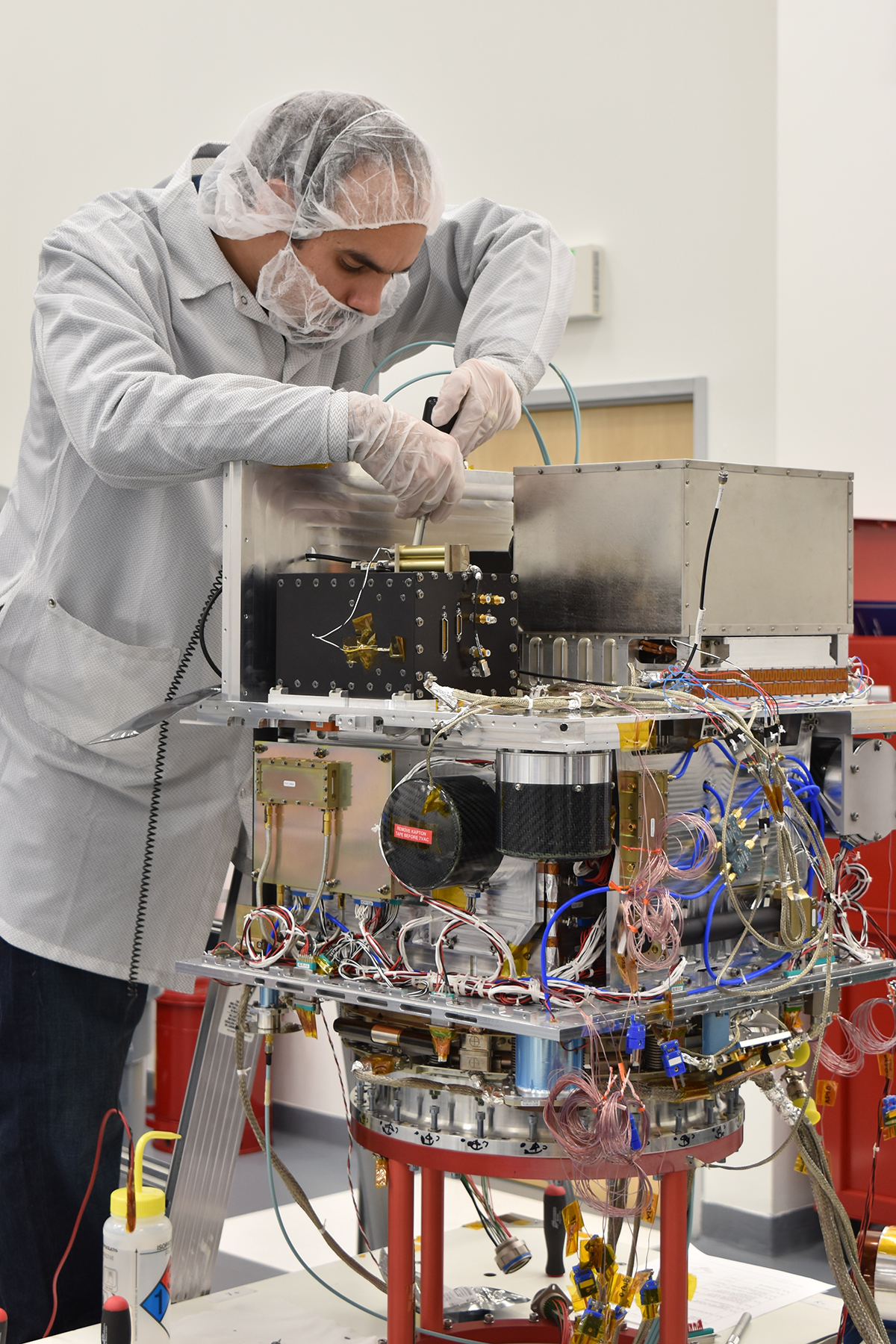
The hardware made that customer relationship tangible. In February 2017, engineers monitored the clock’s integration onto the Surrey spacecraft in Englewood, Colorado. The payload included the atomic clock, a GPS receiver and an ultra-stable oscillator. Timekeeping, usually taken for granted by anyone glancing at a computer, was itself becoming the experiment.
The mission eventually launched in June 2019 aboard a Falcon Heavy. NASA concluded the clock demonstration in September 2021 after more than two years of operation. Those later milestones belong to the mission and its teams. They also show what became of one of the shared-platform projects Gerull had been explaining years earlier.
A picture needs a next visit
Gerull’s Surrey-era discussions also concerned the changing economics of observing Earth. In a January 2015 interview, he emphasized small-satellite constellations, frequent revisits and the combination of video and mapping capture. The ambition concerned how often a customer could see a place, as well as how clearly.
That distinction changes the question an image can answer. A picture records a moment. Returning to the same place lets an observer compare moments. A customer interested in activity has a different requirement from someone who needs a single map. Gerull was discussing platforms and missions designed around those differences.
Surrey’s announced V1C design put numbers beside the proposition in 2014: a ten-kilometer video swath, better-than-one-meter ground sampling and a stated price below $20 million. These were announced specifications and pricing for a design. Gerull linked the product’s economics to customers needing quick understanding of activity on the ground, including business analytics and geospatial intelligence.
The business needed people to develop those opportunities. In August 2015, Stephen Eisele and Rick Sanford joined Surrey Satellite US’s business-development team, reporting to Gerull. Their remit included expanding the company’s work in the American aerospace market. Selling a spacecraft remained an undertaking conducted on Earth, through conversations about customers, missions and money.
The last mile belongs to people
In April 2019, Gerull wrote as AllSource Analysis’s chief technology officer about another part of the same chain. Its model brought software tools, geographic content and a network of experienced analysts together. More available data created opportunities, but organizations did not necessarily have the budgets to employ all the expertise they needed.
“They want information.”Doug Gerull, writing at AllSource Analysis, 2019
His emphasis was on what customers could understand about the effects on their businesses and communities. Governments, nonprofits and commercial organizations needed help making sense of what was happening. The analyst network was intended to make that expertise available when it was required.
Set that beside the desk in the original WorldView pitch. The distance from spacecraft to screen was only one part of the journey. Gerull’s work had moved through optics, mapping software, an early imaging company, satellite manufacturing and interpretation. At each stage, somebody else needed a usable result. The desk stayed put. Much of the interesting work happened on the way there.