Somewhere off the North Sea coast, an offshore operator needs to know what lies in the path of a drilling rig’s anchors. The question sounds simple. The usual answer can involve booking a specialized vessel, putting a remotely operated vehicle in the water, running survey lines, and waiting for the data to become a report. The vessel is often the largest bill. Bedrock Ocean Exploration, a Richmond, California company, has made a business out of asking whether that whole sequence can move faster.
- Bedrock builds and operates electric autonomous underwater vehicles, or AUVs, for seabed surveys.
- Its software plans missions, monitors vehicles and turns sonar readings into shareable maps.
- Its customers span offshore energy, subsea infrastructure, environmental work and maritime security.
- The strongest evidence is operational: better field efficiency, a working two-vehicle survey and a reported North Sea cost comparison.
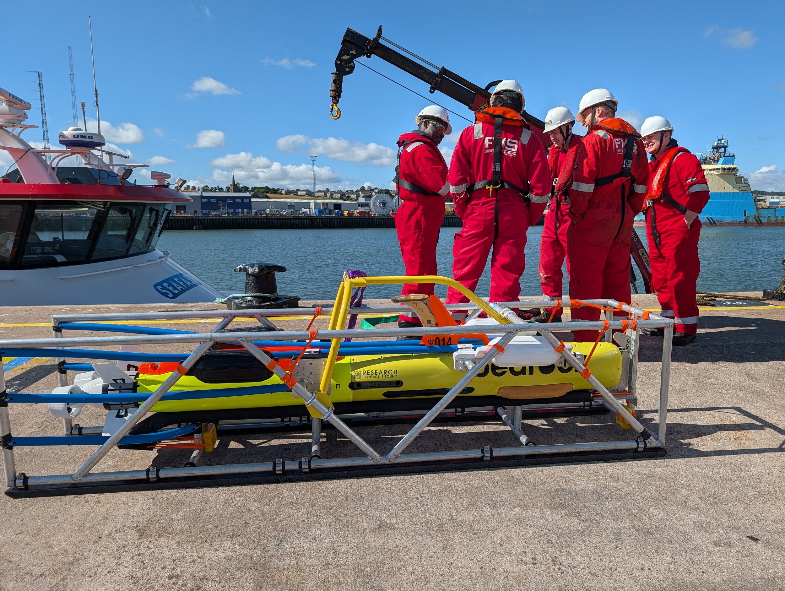
In one 2026 North Sea job, First Marine Solutions launched Bedrock AUVs from a spot-hire platform supply vessel to inspect planned anchor corridors, mooring lines and hazards. Its published case study says the approach cost about 79% less than using a traditional survey vessel and about 92% less than an anchor-handling vessel with an ROV. Those are figures for that job, with its own scope and vessel options. Still, they explain why a small machine below the surface can change the economics above it.
The expensive part was never just the boat
A survey vehicle is useful only if it returns reliable information in time for somebody to act. Bedrock’s vehicles carry multibeam sonar for seabed shape, side-scan sonar for imagery and magnetometers for subtle magnetic changes. They travel close to the bottom, often roughly five to ten meters above it, where a lower-power sensor can see fine detail. That proximity is a strength, but it narrows the strip each vehicle covers. Bedrock’s answer is a fleet rather than a single heroic robot.
The company’s origin was grander than a rig survey. Founded in 2019 as a public benefit corporation, it announced an ambition to map the oceans and make the results more accessible. Co-founder Anthony DiMare wrote the early public essays; co-founder Charles Chiau led the technology and later served as CEO and CTO. In April 2026, Matthew Tirman became CEO while Chiau stayed on as CTO. The mission remains visible, but the commercial offer has become more pointed: acquire seabed data for an actual decision, and deliver it before the decision window closes.
This is also why Bedrock builds more than hardware. Mosaic is its cloud-based home for planning, processing, viewing and sharing survey data. Trident is the command layer for monitoring and coordinating vehicles. Onboard checks tell a crew whether a survey is collecting good data while the equipment is still in the field. Put together, the products turn a survey into a sequence that can be repeated: plan, operate, validate, share.
The screen that stole half a survey
The revealing episode in Bedrock’s history is a 2023 field test in Monterey Bay. The team measured “operational efficiency” as the share of field time spent collecting data. The first reading was 49%. Nearly half the day went to other work, much of it debugging vehicle faults. An underwater robot can have excellent sonar and still be a poor survey business if its operators spend their hours interpreting alarms.
Bedrock adjusted the thresholds and responses in its onboard fault detection system, then changed the operator interface so faults were easier to understand. In the next field test, the company reported 83% operational efficiency. That is a striking improvement, though it comes from Bedrock’s own test series. It suggests a lesson larger than marine robotics: when a machine works in a hard-to-reach place, the diagnostic screen is part of the machine.
Another test showed the fleet idea in miniature. In December 2023, two AUVs mapped adjacent patches with a planned 57-meter overlap. Their bathymetry agreed within 0.02 meters in that shared strip, according to Bedrock’s account. The result did not mean that the ocean could suddenly be mapped on a schedule. It did show that two independently collected datasets could join into one useful surface. For a company whose ambition depends on running fleets, that is the quiet kind of milestone that matters.
“The pot at the end of the rainbow that everybody has been chasing for 20 years has been, can we replace traditional ships?”Brandon Mah, Bedrock COO, in a 2025 interview
A map is only useful if it arrives
Bedrock’s alternatives are familiar to any marine survey buyer: a crewed survey ship, an anchor-handling vessel with an ROV, or another autonomous platform. The comparison depends on the job. A ship can provide sub-meter positional accuracy; Bedrock told TechCrunch that its underwater vehicles place seabed items within about one to two meters because GPS disappears below the surface. Its vehicles must surface for position updates, and working close to the seabed limits the area one machine covers. A project demanding the tightest positioning or very broad single-pass coverage may still justify a conventional vessel.
The opposite case is an operator who needs repeated, targeted answers across several sites. In the North Sea debris survey, the AUVs followed pre-programmed corridors and held a consistent altitude above the seabed. Multibeam and side-scan readings came from the same platform, making it easier to compare a suspicious acoustic mark with the height of the object casting it. Onboard checks helped confirm coverage before the crew left the field. The value was not a prettier map. It was fewer reasons to return to sea.
Bedrock’s business model follows that logic. It owns the vehicles and offers survey results and intelligence rather than asking every customer to build an AUV program. Its September 2026 argument to navies went further: buy undersea awareness as a service, with the supplier responsible for the fleet. Commercial terms are not public, so the model is clearer than the price. The company raised an $8 million seed round in 2021 and a $25 million Series A-2 round in 2025 to keep developing that stack and putting it in the water.
The next deployment is a partnership
The Aberdeen arrangement shows what scaling the model requires. Bedrock placed vehicles at First Marine Solutions’ base and trained local operators to use Mosaic, Trident, onboard reports, and launch and recovery procedures. The first certification took five days in August 2026: two in the classroom and three on the water. That lets a regional survey company run Bedrock-owned technology without shipping crews and equipment from California for each assignment. It is a practical answer to the question every remote hardware company eventually faces: who fixes and runs it when it is far from home?
Defense customers raise a different problem. A sensor can gather excellent data and still fail to fit an existing command system. During a 2026 U.S. Navy exercise, Bedrock, Integer Technologies and Liquid Robotics linked an AUV, a Wave Glider surface vehicle and shore-based mission views. The demonstration was about getting the right position and survey information through constrained communications, not filling a screen with raw sonar. For a Navy operator, the relevant product may be a timely change in the seabed picture rather than another vehicle to maintain.
The ocean still resists tidy plans. Weather, vessel availability, underwater navigation drift, sensor altitude and data quality all decide whether a survey earns its keep. Bedrock’s most persuasive claim is therefore modest and testable: if you can launch smaller vehicles from more vessels, see faults sooner, coordinate a fleet and deliver a usable dataset quickly, more questions become worth asking. The map becomes a working instrument. The robot is the way to get there.